
Trek Grade
Easy - Moderate
Highest Altitude
12100 Ft
Base Camp
Sari
Best Time
Round the year except Monsoon
Trek Distance
22 Km
Not sure which trek is right for you? Trekup India’s Mountain Experts have you covered.
Not sure which trek is right for you? Trekup India’s Mountain Experts have you covered. From figuring out if a trek matches your fitness level to knowing who you’ll be trekking with, we’re here to answer all your questions. Reach out to our Mountain Experts and plan your trek with confidence.
Chopta Chandrashila Tungnath Deoriatal Trek
The Chopta Chandrashila Tungnath with Deoriatal Trek combines four incredible destinations into one unforgettable 5-day adventure in Uttarakhand’s stunning Himalayan landscape. This easy-to-moderate trek takes you to the world’s highest Shiva temple at Tungnath, up to the breathtaking Chandrashila Summit at 12,000 feet, and includes the pristine emerald waters of Deoriatal Lake.
Perfect for both beginner trekkers and experienced hikers, this 23-kilometer journey offers something special for everyone. Families, solo travelers, adventure groups, and spiritual seekers will all find their own reasons to love this trek. You’ll get incredible mountain views without the extreme difficulty of other Himalayan treks.
We’ll walk you through everything you need to know about this amazing trek. First, you’ll discover the key destinations and what makes each spot special – from the sacred Tungnath Temple to the mirror-like reflections at Deoriatal. Then we’ll cover the spectacular mountain views you can expect, including glimpses of Nanda Devi, Chaukhamba, and other mighty peaks. Finally, we’ll share the detailed itinerary so you know exactly what to expect each day of your adventure.
Key Destinations and Attractions
Chopta – Mini Switzerland of Uttarakhand
You’ll find yourself mesmerized by Chopta, often referred to as the “Mini Switzerland of Uttarakhand.” This quaint hill station serves as your base camp for the remarkable journey ahead, offering pristine views of the Nanda Devi, Trishul, and Chaukhamba peaks. Located at an altitude of 2,680 meters, Chopta provides you with the perfect setting to begin your trekking adventure through enchanting rhododendron forests and rolling meadows.
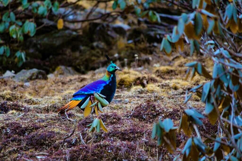
As you arrive in this serene mountain settlement, you’ll notice the untouched beauty that makes Chopta a haven for nature enthusiasts. The region is renowned for its rich biodiversity, where you can spot rare Himalayan species including the vibrant Himalayan Monal, the state bird of Uttarakhand. The dense forests surrounding Chopta are home to oak, pine, and burans trees, creating a natural paradise that feels like stepping into another world.
Your experience in Chopta becomes even more special with its proximity to the Kedarnath Wildlife Sanctuary. This sanctuary offers you the opportunity to witness diverse wildlife and rare bird species, making it an ideal location for birdwatching and photography enthusiasts.
Deoriatal Lake and Chaukhamba Reflections
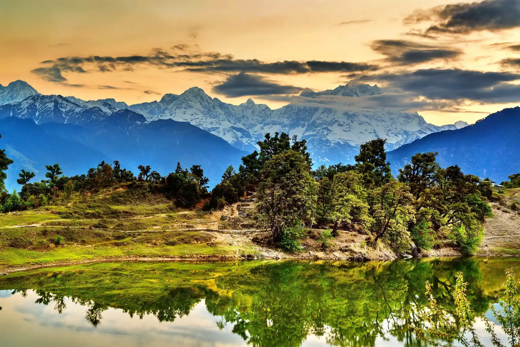
Your trek to Deoriatal presents one of the most enchanting experiences on this journey. Situated at 2,400 meters above sea level, this pristine alpine lake provides you with a surreal sight that will remain etched in your memory forever. The lovely alpine lake is nestled beautifully in a mountain clearing and surrounded on all sides by the majestic Garhwal Himalayas.
When you reach Deoriatal, you’ll witness Mount Chaukhamba casting its magnificent reflection on the lake’s still waters – a surreal sight to behold. The tranquil Deoriatal Lake showcases stunning reflections of the surrounding peaks, creating picture-perfect moments that make it a peaceful spot to pause and admire nature’s artistry. The clear waters of Deoriatal, with the majestic peaks mirrored on its surface, create an enchanting scene that adds to your trek’s allure.
Your journey to Deoriatal involves a relatively easy 3-kilometer trek from Sari Village, taking approximately 1-1.5 hours. The trail to Deoriatal features mixed ascents and descents along the way, making it accessible for trekkers of various skill levels. This location provides you with the perfect dreamy setting for camping, where you can enjoy the serenity scattered around this place with evening sunsets and glittering sunrises in the morning.
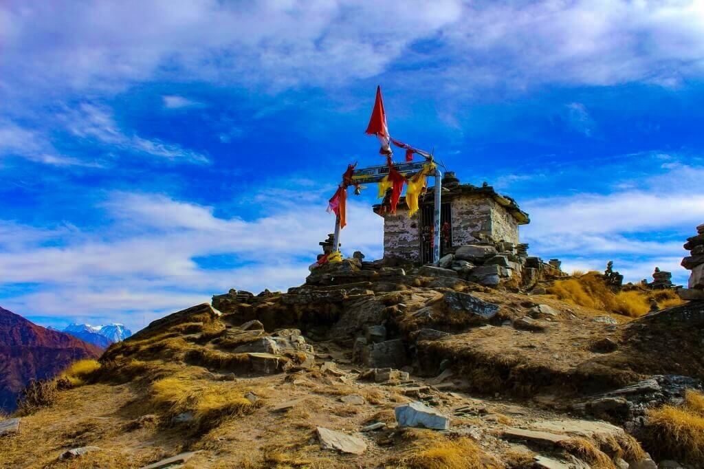
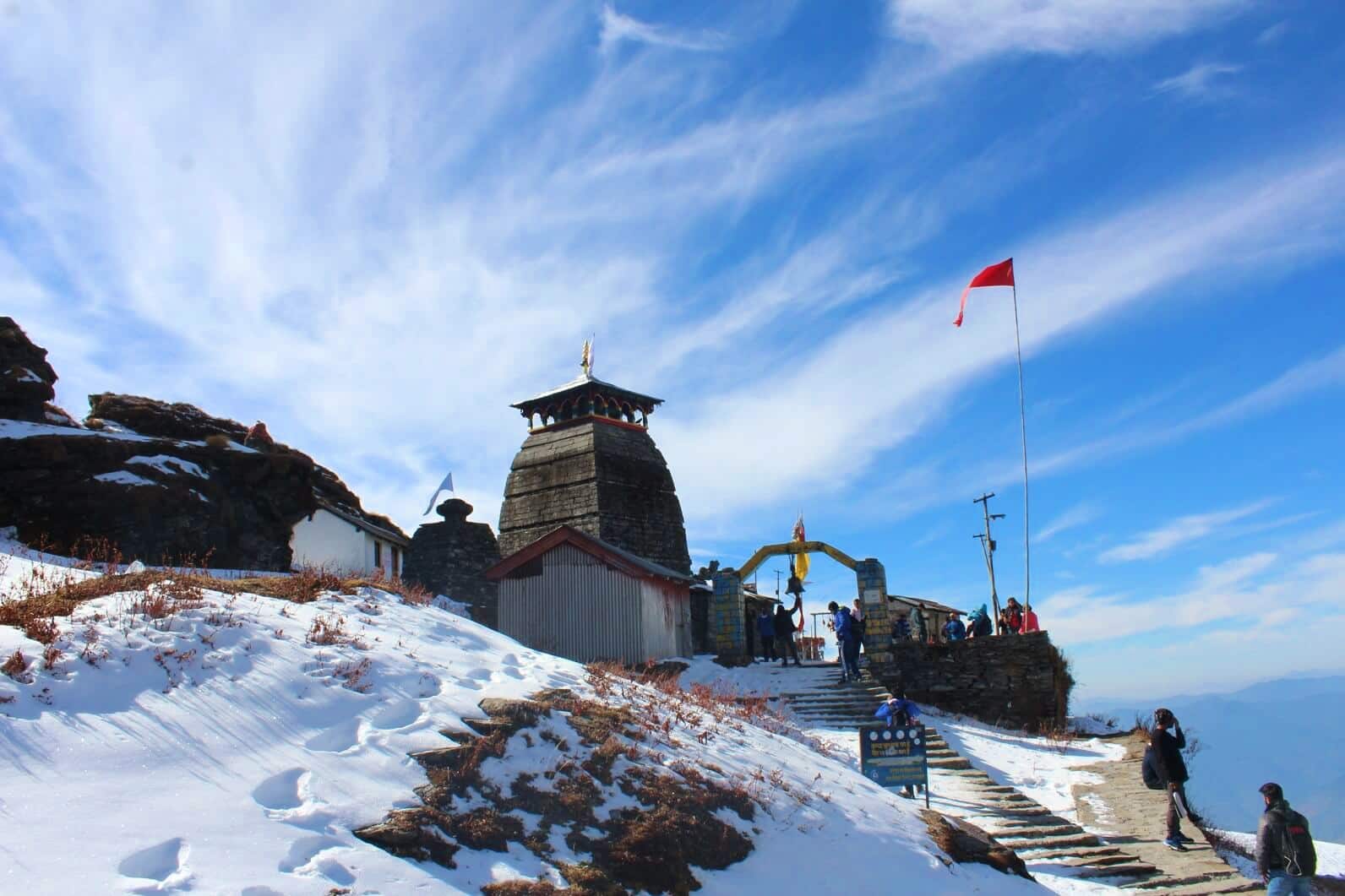
Tungnath Temple – World’s Highest Shiva Temple
You’ll embark on a spiritually significant journey to Tungnath Temple, the highest Shiva temple in the world, perched at an impressive altitude of 3,680 meters (12,073 feet). This ancient stone structure holds immense mythological importance as one of the revered Panch Kedars, believed to have been built by the Pandavas in their quest for Lord Shiva’s forgiveness after the great battle of Kurukshetra.
According to Hindu mythology, when the Pandavas sought Lord Shiva’s blessings to atone for their sins, Shiva took the form of a bull and hid himself in different parts of the Himalayas. The Tungnath Temple marks the sacred place where the bull’s hands are believed to have emerged, making your visit here an act of devotion and penance.
Your trek to Tungnath begins from Chopta and covers approximately 3.5-4 kilometers through well-paved, gradually ascending trails. The journey takes you 3-4 hours to complete, offering stunning views of beautiful Garhwal peaks including Mt. Trishul, Nanda Ghunti, Nanda Devi, Chaukhamba, Thalaysagar, Gangotri Ranges, and Kedardome along the way. The temple’s peaceful surroundings create an ambiance that feels timeless and sacred, where the history and legends associated with Tungnath infuse your journey with a deep sense of reverence and spirituality.
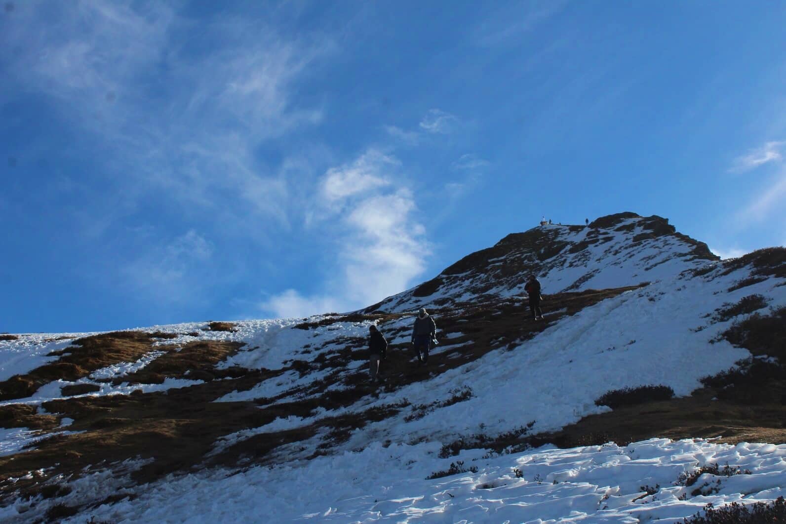
Chandrashila Peak Summit Experience
Your adventure reaches its crescendo at Chandrashila Summit, situated at 4,000 meters (13,000 feet) above sea level. From Tungnath Temple, you’ll continue for another 1.5 kilometers on a steeper but rewarding climb to reach this breathtaking summit. The ascent to Chandrashila Peak is challenging yet exhilarating, as the trail becomes more rugged and demanding.
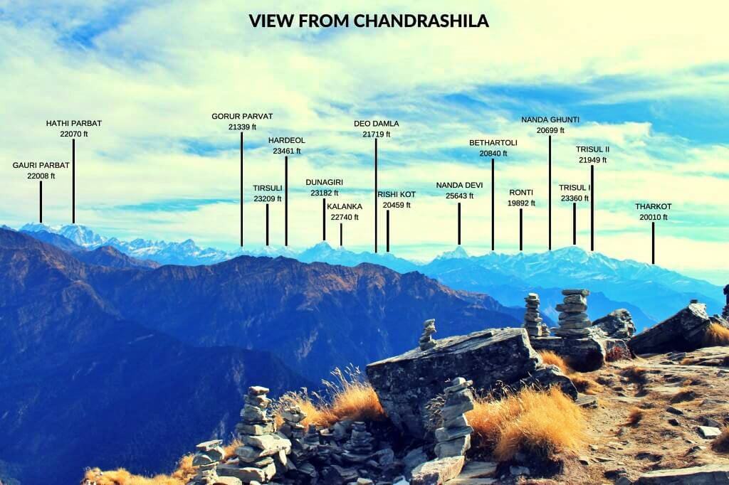
At the summit, you’ll be rewarded with mesmerizing 360-degree panoramic views of the Himalayas, including towering giants such as Nanda Devi, Trishul, Chaukhamba, Kedar Dome, and many more snow-capped peaks standing like guardians over the Garhwal region. The sight of these mountains bathed in the soft light of dawn or silhouetted against a clear blue sky provides you with a visual feast that lingers long after your trek is over.
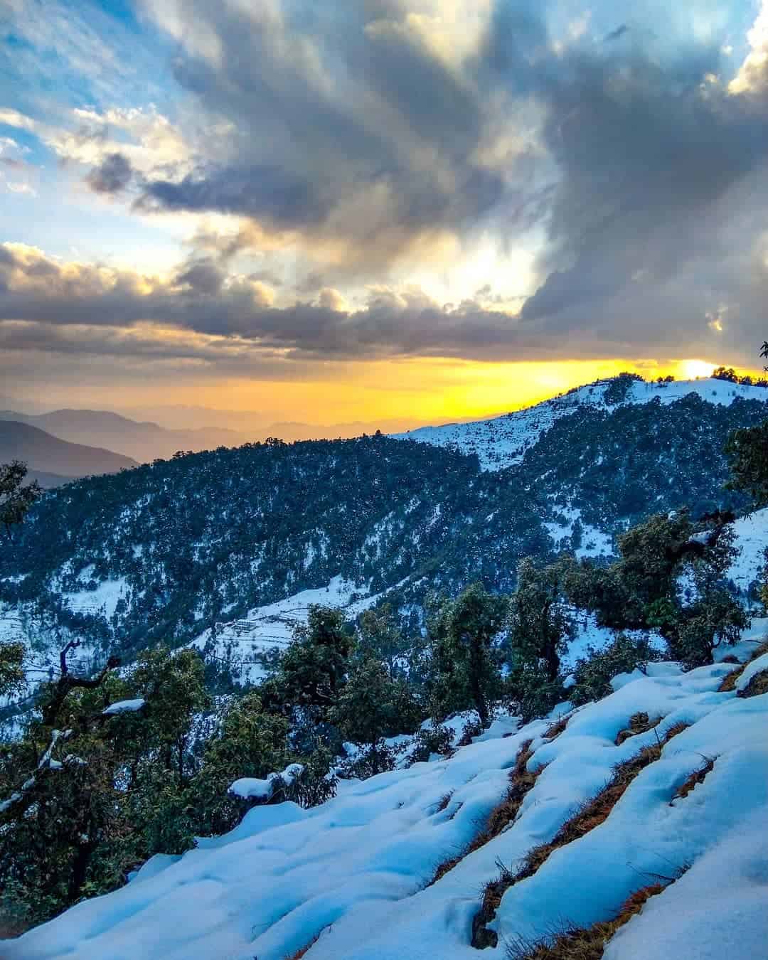
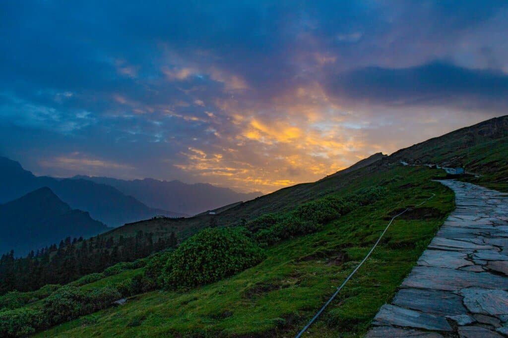
One of the most spectacular highlights you’ll experience is witnessing the sunrise from Chandrashila Summit. You’ll need to set out in the early pre-dawn hours to reach the top just as the first light breaks over the horizon. The sky transforms into vivid shades of gold, orange, and crimson, casting a radiant glow over the surrounding mountains. This spectacular sunrise, with its serene and almost spiritual atmosphere, represents a moment of pure magic often described as the crowning glory of your entire trek.
According to legend, Chandrashila Summit holds mythological significance as the meditation site of Lord Rama, where he meditated after defeating Ravana. The summit also marks the spot where the moon god, Chandra, performed a yajna (ritual sacrifice) to gain Lord Shiva’s blessings, hence the name “Chandrashila,” meaning “Moon Rock.”
Spectacular Mountain Views and Natural Beauty
360 Degree Himalayan Peak Panorama
When you reach the summit of Chandrashila Peak at 12,083 feet, you’ll be rewarded with one of the most magnificent 360-degree panoramic views in the entire Himalayan range. The summit offers unobstructed vistas that will leave you speechless as you gaze upon the majestic Himalayan jewels spread across the horizon. From this vantage point, you can witness the grandeur of several towering peaks including Thalaysagar (6,904 m), Kedar Dome (6,832 m), Kedarnath (6,940 m), Sumeru (6,350 m), Neelkanth (6,596 m), Janhukut (6,805 m), Chaukhamba (7,138 m), and Dunagiri (7,066 m).
The experience feels almost surreal as you stand atop this peak, which appears to be adorned with a beautiful necklace of precious gems tied around its neck. The sweeping views encompass the entire Garhwal Himalayan range, creating a sense of accomplishment that washes over you as the peace and tranquility of this sacred summit momentarily seduces you to connect with your truest self.
Snow Capped Peaks Including Nanda Devi and Trisul
Your panoramic adventure from Chandrashila Summit becomes even more spectacular when you witness the crown jewels of the Himalayas – the magnificent snow-capped peaks of Nanda Devi and Trisul. Rising majestically at 7,816 meters, Nanda Devi stands as one of India’s highest peaks, while Trisul towers at 7,120 meters, both creating an awe-inspiring backdrop that dominates the northern horizon.
These snow-covered giants present themselves in all their glory, especially during the clear morning hours when sunrays wash over the pristine white snow, making it sparkle almost like what you would imagine the floor of the moon to resemble. The brilliant white peaks contrast beautifully against the deep blue sky, creating a visual spectacle that photographers and nature lovers dream of capturing. The sight of these towering summits covered in eternal snow serves as a reminder of nature’s raw power and untouched beauty, making your trek to Chandrashila truly a journey to the moon and back.
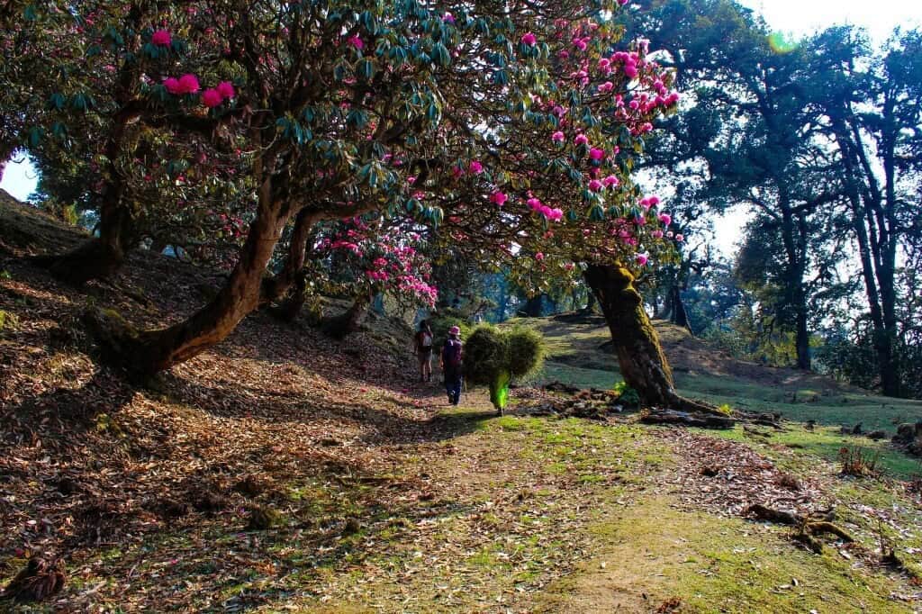
Rhododendron Forests and Alpine Meadows
As you traverse the Chopta Chandrashila Trek, you’ll be enchanted by the diverse flora that transforms this region into a natural wonderland. The trail winds through some of the most beautiful pink-dressed rhododendron trees that welcome trekkers with their sheer vibrancy and spectacular colors that nature has bestowed upon them. These magnificent rhododendron forests create a tunnel of blooms during the flowering season, offering you an almost magical walking experience.
The trek takes you through abundantly blessed forests of larger-than-life pines, oaks, and blossoming rhododendrons, creating a diverse ecosystem that supports various wildlife species. You’ll also encounter pristine alpine meadows that stretch across the landscape, providing perfect spots for rest and photography. The lush green meadows are interspersed with dense forests of deodar, pine, and oak trees, creating a varied terrain that keeps your journey interesting and visually appealing.
During the right season, you might witness a rich variety of vibrant wildflowers carpeting the meadows, adding splashes of color to the already stunning landscape. The combination of rhododendron forests and alpine meadows creates a perfect backdrop for your Tungnath Temple and Chandrashila Summit adventure.
Wildlife Spotting Opportunities
Your trek through the Deoriatal Chandrashila Trek route offers excellent opportunities to encounter the rich wildlife that inhabits this pristine Himalayan ecosystem. As you walk through the dense forests of rhododendron, pine, and deodar, keep your eyes peeled for some fascinating Himalayan species that call this region home.
You might spot the elusive musk deer gracefully moving through the forest undergrowth, or catch a glimpse of the spectacular Himalayan Monal, a colorful bird that’s considered the state bird of Uttarakhand. The forests also provide habitat for black bears, though these magnificent creatures are typically observed from a safe distance. The diverse ecosystem supports various other bird species, and you’ll likely hear their melodious chirping echoing through the valleys as you make your way toward the Tungnath Temple and beyond to Chandrashila Summit.
The wildlife viewing opportunities are particularly rewarding during the early morning and late afternoon hours when animals are most active. Remember to maintain a respectful distance from any wildlife you encounter and follow responsible trekking practices to preserve this delicate mountain ecosystem for future generations.
Trek Cost
-
Pickup from Natraj Chowk, Rishikesh at 6.30 A.M & On last day we will drop you at same location by 7 P.M
-
+₹1600 Extra For Transport
Fix Departure Dates!
Trek Cost Inclusions and Exclusions!
Trek Cost Inclusions
- Stay: Comfortable Guesthouse or Swiss Cottage Tents, with separate arrangements for males and females on triple, quad, or multi sharing basis for a cozy and convenient stay.
- Meals: Trekup India will provide freshly cooked meals during the trek starting with dinner on Day 1 to dinner on day 4 (Meals are simple, nutritious, and vegetarian + Egg)
- Transport: Rishikesh to Sari and return. (Extra 1600)
- Trek Insurance (Optional) (At Extra Cost): Trekup India recommends that all trekkers consider getting trek insurance. This is optional, but highly recommended. Trek insurance covers unexpected events that may occur during your trek. The cost of the insurance starts from INR 210. Please read more about what is included in the coverage and why it is mandatory on treks.
- Trek Equipment: Sleeping bag, Sleeping tents, Kitchen tent, Dining tent, Toilet Tent.
- Amenities: All utensils, sleeping mattresses (Black foam mats), Crampons, and Gaiters for snow.
- Health & Safety: First Aid Box, Oxygen Cylinders, Stretchers, Oxi meters, BP Machines, health.
- Permits: Forest Permits and Camping Permission Fee
- Trek Crew: High Altitude Chef, Helpers, Trek Leader & Guides, and other support teams.
- Potters & Mules: Potters and Mules are to carry all trekking equipment, ration, and vegetables.
Trek Cost Exclusions
- GST 5% (it is Mandatory)
- Deoriatal (additional ₹500 and is Optional).
- Any Meals/accommodation beside the itinerary or not mentioned in the program.
- Any Bus / Airfare to/from trek start/end point
- Personal Medical expenses do carry your medication.
- Any personal services such as Laundry, phone calls, liquors, mineral water, etc.
- Please note that transport between Sari and Chopta is excluded unless the full Rishikesh-to-Rishikesh transportation package is availed.
- Any still / video camera fee
- Any Entrance fee Monuments, Monasteries, Museums, Temples – Pay directly on the spot.
- Any emergency evacuation charges
- Any services that are not mentioned in the cost inclusion section.
Chopta Chandrashilla Tungnath Deoriatal Trek Videos
Videos by experts watch these videos to prepare well for a Successful Trek
Want To Trek Like Pro?
Basically, watch these videos if you want to trek the same way professional trekkers do and make your skills better. These videos contain useful tips and techniques to further improve your trekking skills itself. These videos actually help both new and experienced trekkers improve their trekking skills. These videos definitely provide useful tips that make your trek better. We are seeing that these videos by Trekup India experts will only help you make your trekking skills better.


Know Everything About Acute Mountain Sickness
Acute Mountain Sickness occurs when people trek to high altitudes above 8,000 feet. This condition itself develops further due to reduced oxygen levels at such heights. Basically, as you go higher up, the air pressure and oxygen levels decrease, which causes the same problem. Acute Mountain Sickness surely causes headache, nausea, vomiting, and dizziness in affected persons. Moreover, peoples also experience difficulty in sleeping during this condition. To avoid mountain sickness, you should actually trek up slowly to higher altitudes. To learn further about this condition itself, watch the videos by Trekup India.


Day Wise Detailed Itinerary of Chopta Chandrashilla Tungnath Deoriatal Trek
Day 1: Drive From Rishikesh to Sari
- Pick-up Point: Rishikesh Natraj Chowk
- Pick-up Time: 6:30 AM sharp
- Distance: Approximately 190 km by road
- Travel Duration: Around 7 hours (depending on road conditions)
- Destination Altitude: 6,600 feet
- Network Availability: Available until Sari; limited beyond
Your journey from Rishikesh to Sari village marks the beginning of an incredible Chopta Tungnath adventure.
You’ll travel 192 kilometers through breathtaking mountain landscapes, passing through significant stops like Devprayag where two sacred rivers meet. We’ll cover the essential driving route details and timing to help you plan your departure from the yoga capital of the world. You’ll also discover what makes Sari village the perfect base camp for both the Deoria Tal trek and your upcoming Tungnath temple journey.
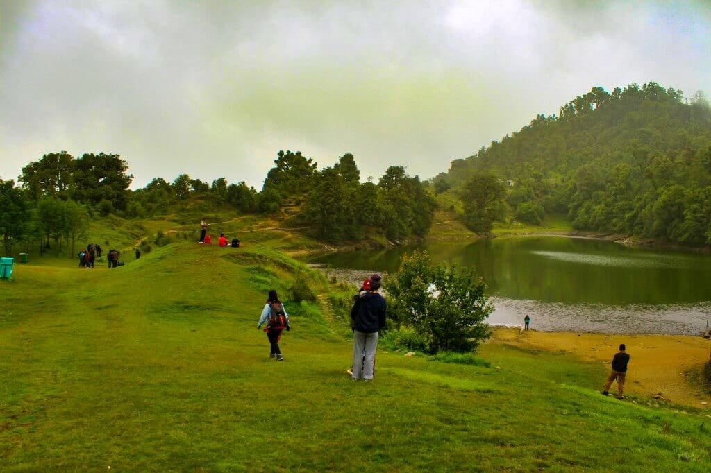
Day 2: Trek to Deoriatal - The Lake of the Gods
- Trek Duration: 1.5-2 hours (easy to moderate)
- Altitude Gain: 450 m
- Starting Point: Sari Village (base with electricity & mobile network)
- Lake Altitude: 2,438 m (7,999 ft)
Deoriatal is famous for its crystal clear reflections of Chaukhamba peaks and its 300° panoramic view of the Himalayas – including Nilkantha, Bandarpunch, and Kedar Range. Surrounded by oak and rhododendron forests, it’s an ideal stop for beginners, families, and nature lovers.
Mythological Connection
According to the Mahabharata, Deoriatal is where Yudhishthira encountered the Yaksha who tested his wisdom. When his four brothers ignored the divine warning and drank from the lake, they fell lifeless – only Yudhishthira’s righteousness saved them. Hence, the lake earned its sacred name, “Devariya Tal” – the Lake of the Gods.
Why Visit
Deoriatal offers a perfect blend of spiritual calm and Himalayan grandeur, serving as both a serene destination and the gateway to the Tungnath Chandrashila trek. Its accessibility and legendary aura make it one of the most rewarding short treks in Uttarakhand.
Day 3: Deoriatal to Baniyakund via Tala Village
- Trek Distance: 10 km | 6–7 hrs
- Stay: Cottages / Swiss Camps (triple, quad, or dorm)
Your final day begins with a peaceful descent from Deoriatal (2,400 m) to Tala Village (2,000 m), followed by a 15 km scenic drive (45 min) to Baniyakund (2,600 m) – your overnight stop before the Chandrashila summit day.
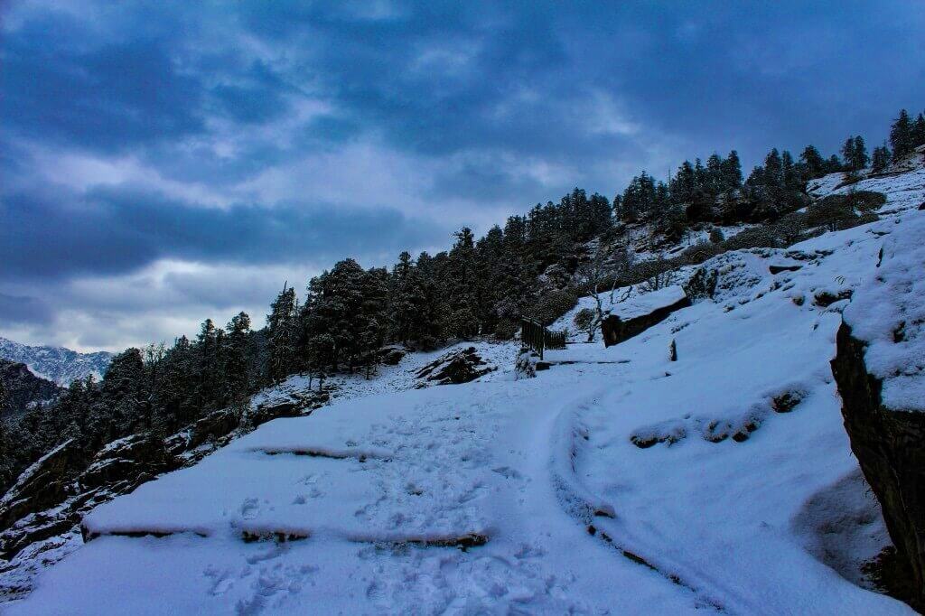
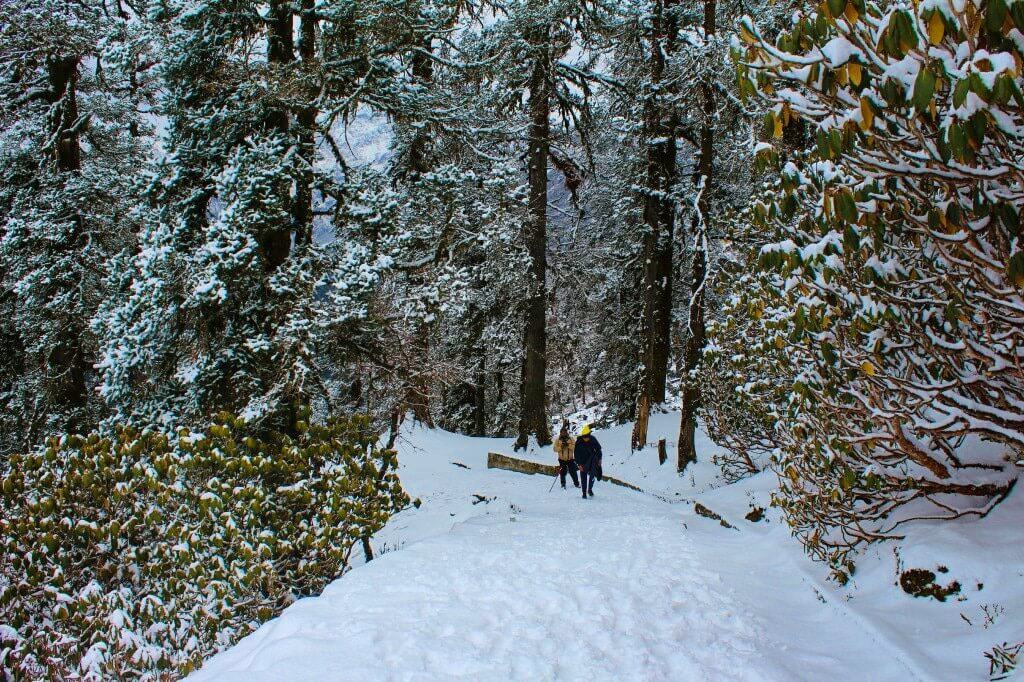
The trail winds through rhododendron and oak forests, offering glimpses of Chaukhamba and Kedarnath peaks. In spring, it’s vibrant with red blooms; in winter, it turns into a snowy wonderland.
You’ll pass through parts of the Kedarnath Wildlife Sanctuary, where sightings of Himalayan Monal, red foxes, and colorful birds are common. Small shrines and prayer flags mark the route, adding to the mountain charm.
By evening, you’ll reach Baniyakund, surrounded by meadows and views of Chandrashila Peak – the perfect spot to relax and prepare for your summit adventure ahead.
Day 4: Baniyakund – Chopta – Tungnath – Chandrashila – Baniyakund
- Drive: Baniyakund – Chopta (15 min)
- Trek Distance: 9-10 km round trip
- Duration: 7-8 hrs total
- Altitude Gain: 8,550 ft – 13,100 ft
- Chopta: 2,850 m / 9,400 ft
- Tungnath: 3,500 m / 11,500 ft
- Chandrashila Summit: 3,700 m / 12,000 ft
The Summit Day
Your final and most awaited day begins before sunrise. After an early breakfast, take a short 5 km drive from Baniyakund to Chopta, fondly known as the Mini Switzerland of India. From here, your summit trek begins – a journey that blends adventure, spirituality, and panoramic Himalayan beauty.
The 4-5 km trail from Chopta to Tungnath is well-defined and gradually ascends through rhododendron forests and open meadows. As you climb, enjoy sightings of Monal pheasants, Griffon vultures, and other Himalayan birds. With every step, the snow-capped Chaukhamba and Kedarnath peaks come into view.
Tungnath Temple – The Highest Shiva Shrine
At 11,500 ft, you’ll reach Tungnath, the highest Shiva temple in the world and part of the revered Panch Kedar circuit. Said to be built by the Pandavas in search of Lord Shiva, the temple stands as a symbol of devotion amid the mighty Himalayas. The ancient stone structure, its serene aura, and the surrounding peaks create an experience that’s deeply spiritual and timeless.
Trek to Chandrashila Summit
From Tungnath, continue towards Chandrashila, a steeper 1.5 km climb that rewards every step with breathtaking views. In winter, crampons and gaiters (provided by Trekup India) are necessary as the trail may be icy. The final 30-45 minutes are a steady push to the top, where you stand at 3,700 m (12,000 ft).
The 360° Himalayan panorama from the summit is simply stunning – featuring Nanda Devi, Trishul, Chaukhamba, Kamet, Gangotri, and Kedar Dome.
The Sunrise Moment
Witness the sunrise from Chandrashila, one of the most mesmerizing sights in the Indian Himalayas. As dawn breaks, the snow-clad peaks glow in hues of pink, orange, and gold, creating a dreamlike landscape you’ll never forget. Capture this magical moment before beginning your descent.
Descent & Return
Retrace your steps back to Tungnath and Chopta, then drive back to Baniyakund by evening. Relax in your cozy cottages or Swiss tents, enjoy a hearty dinner, and relive the incredible experience of summiting Chandrashila – a perfect finale to your Deoriatal–Chandrashila adventure.F
Day 5: Baniyakund to Rishikesh – Farewell to the Mountains
- Drop off Point-Rishikesh Natraj Chowk
- Distance- 210 km
- Time: 7 hours time; the destination is expected to be reached at around 6:30 pm.
Today marks the final day of your Himalayan adventure, as you bid farewell to the majestic peaks and serene meadows that have defined your journey.
Wake up early to the crisp mountain air and enjoy a warm cup of tea while soaking in your last views of the Garhwal Himalayas. After breakfast, begin your 7-8 hour drive from Baniyakund to Rishikesh, retracing the scenic mountain roads that now hold countless memories.
Along the way, you’ll pass through charming hill villages, lush valleys, and winding forest roads – a final reminder of the region’s natural beauty. There will be scheduled stops for breakfast and lunch (self paid), giving you time to relax and reflect on your unforgettable trek.
As you descend towards the plains, each turn offers a moment to relive the summit of Chandrashila, the spiritual calm of Tungnath, and the peaceful reflections at Deoriatal.
By evening, you’ll reach Rishikesh, where you’ll be dropped at Natraj Chowk Rishikesh – the official endpoint of your trip.
Though the trek concludes here, the magic of the mountains will travel home with you – in your memories, your spirit, and your heart. The Chopta-Chandrashila Trek isn’t just a journey you complete. it’s an experience that stays with you long after you’ve left the trails behind.
We’ve prepared a comprehensive Trek Route Map for your upcoming adventure to Chopta Chandrashilla Tungnath Deoriatal Trek, which outlines the entire journey including all stops and trails. This map provides detailed information on the terrain, distance between points of interest, and estimated travel time to help ensure a safe and enjoyable trek. We’ve carefully curated the map to ensure that you have all the necessary information at your fingertips. Please take a moment to review it thoroughly, and don’t hesitate to reach out if you have any questions or concerns.
The Trek Altitude Chart is a useful tool for Trekkers to monitor their altitude changes during their rides, allowing them to plan their routes more efficiently and track their progress over time. This Chopta Chandrashilla Tungnath Deoriatal Trek chart is beneficial for both casual and experienced Trekkers, helping them make the most out of their Trek experience.
What should you pack for the Chopta Chandrashilla Tungnath Deoriatal Trek
Chopta Chandrashilla Tungnath Deoriatal Trek is a high-altitude trek. The trekking gear you have to have for this particular trek differs from normal treks. Thus, read this whole segment. There is an important question that the trekker who is doing trek asks, like what all things to carry while trekking. Below, we have provided the details on everything you should take; an easy way to remember is by Head to foot or foot to head. We have prepared from Head to foot.


Head Gears
When trekking it's important to carry headgear to protect your head and face.
Heading out for a trek? Don’t forget to carry headgear to protect your beautiful face and head from the sun, wind, and dust! It’s an essential accessory that keeps you safe and comfortable throughout your adventurous journey. So, make sure you pack it before you step out into nature!
- Head Lamps are essential for the night, and most importantly, headtorchs keep your hands free while trekking.
- Hats or Cap– Cap will protect you from winds and sometimes freezing temperatures for the night. Hats protect you from the sun during the day and also ensure they have a strap so the hat doesn’t blow from the wind.
- Sunglasses– you will need specific sunglasses for trekking. The glasses should protect from UV rays, fit your face perfectly so it doesn’t fall while you climb, jump, or cross an obstacle, and be according to the weather conditions of the place; the glass should be made to fit different weather conditions.
- Buff / Balaclava– You must carry this to protect your mouth or neck from extreme temperatures and keep it warm.
Clothes
When trekking in high altitudes, prepare for cold weather by wearing layers. Layering traps heat, keeps you warm, and allows you to easily adjust your clothing as temperatures fluctuate.
Layering is important for different seasons when trekking. When planning a high-altitude trek, it is important to prepare for the cold weather. Wearing layers is the best approach as it provides both protection and flexibility when the weather changes frequently in the mountains. Layering helps to trap heat and keep your body warm, while at the same time allowing you to easily adjust your clothing as the temperature fluctuates. By wearing layers, you can enjoy your trek comfortably and stay safe in the unpredictable mountain weather
- For spring, summer, and monsoon treks, consider wearing three layers: a woollen sweater, a fleece, and a padded jacket.
- For autumn treks, add one more fleece layer to make it four layers.
- For winter treks, you may need five layers with thermals, a woollen sweater, two fleeces, and a padded jacket.
- T-shirt/sleeve shirt– Bring three T-shirts and two quick-dry trek pants, wearing one and carrying the others. Long sleeve shirts help to protect from sun UV rays. We recommend synthetic T-shirts as they get dry quickly when they get wet.
- Hiking / Trekking Jacket– down jackets (-5 to-10 C) or two-three-layer jackets.
- Thermals– at least two pairs of thermals help keep the body warm during cold weather.
- Undergarments– you can carry them according to your habitual and hygiene requirements.
- Gloves– 1 pair of gloves will keep your hand warm and nice.
- Trek Pants– Bring 2 to 3 comfortable trekking pants. Trekking pants play a significant role, as they are designed for comfort and mobility, making trekking easier. It should be Synthetic so that it gets dry quickly when wet.
- Rain Wear– you can carry a raincoat or Poncho. During long rains and snowfalls, the waterproof jackets start leaking. Still, the Poncho and raincoats keep you dry, so choose accordingly.
Tip: If you choose a raincoat on your trek, carry a small waterproof cover so things inside your backpack can’t get wet. If you carry a Poncho, you don’t need to worry. It protects both you and your backpack.
Foot Gears
When it comes to planning a trek, one of the most important aspects is to ensure that you have the right kind of foot gear.
- Trekking shoes whichare waterproof and have ankle support. Walking / Hiking sandals which can be used off the trek, i.e., in the morning and evening hours when you reach the campsite, basically to get your feet rest from heavy boots, sometimes used for crossing streams and rivers, it’s more comfortable and safer than crossing barefoot or wetting your shoes. Sneakers (Optional) can be worn for normal driving days or used around the camp.
- Socks– you should at least carry 3 to 4 pairs.
- Microspikes & Gaitorswill be provided by Trekup India when required. You don’t have to carry them.
Personal First Aid Kit
Don't forget to pack your personal first aid kit! It's always better to be safe. So, make sure you're prepared for any unforeseen circumstances.
Below are some common medicines generally required/used during your adventure trip; however, please consult your doctors prior.
- Antiseptic towel or water syringe (to clean the wound)
- Butterfly bandage for a small cut
- Cotton and elastic bandages and sterile gauze pad for larger wounds
- Latex gloves are used when the wound bleeds.
- Medicine for Diarrhea (Upset stomach)
- Medicine for cold, flue/fever, headache
- Some pain killers
- ORS pouches
- Quick pain relief spray (External use)
- Any personal medicine prescribed by your doctor
- Dimox / Similar for high altitude sickness
- Bug Repellent
- Carry some nutria/energy bars and drinks (non-alcoholic)
- Note: Kindly consult your doctor before purchasing or taking any medicine.
Gadgets and Other Items
You might also consider bringing a camera, binoculars, portable charger, and snacks. Be well-prepared and tackle any trail with confidence.
- Trekking Poles
- Mobile phone
- Camera
- Spare batteries for phone and camera, power bank
- Lightweight flashlight or headlight
- A waterproof bag made of plastic is used for the camera.
- Plug/converter for electrical items
- 1-litre water bottle
- A journal with a pen would be a good idea to keep your notes.
- Some book of your interest for the ideal time
- Get into the habit of maintaining a Map and guidebook of the region.
Hygiene & Personal toiletry
Remember to pack hygiene and personal toiletry items such as soap, shampoo, toothbrush, toothpaste, deodorant, and toilet paper.
- Sunscreen with UV protection
- 1 or 2 small quick-drying towels
- Toilet paper/tissues/wet wipes
- Toothbrush/toothpaste/ mouth freshener
- Deodorant / Talcum powder
- Shampoo
- Lip-gloss/salve
- Sanitary pads/tampons (For female trekkers)
- Bio gradable Soap
- Nail clipper
- Your other personal items that you use daily.
Compulsory Documents to Carry
There are certain documents that you should always carry with you. These documents are not only necessary for your safety and security, but they may also be required by local authorities.
These files must be submitted to the Forest Department before your trek. With none of these, you will not be permitted to trek—original and photocopy of government photo identity card. Carry IDs like Aadhaar, voter ID, etc.
How To Plan Your Trek & Reach Rishikesh?
Railway Connections via Haridwar and Rishikesh
If you’re planning to reach the Chopta Chandrashila Tungnath trek via train, Haridwar and Rishikesh serve as your primary railway gateways. Both stations are well-connected to major cities across India, making them convenient starting points for your journey. From Haridwar, you’ll need to cover approximately 226 kilometers to reach Chopta, while Rishikesh is slightly closer at 206 kilometers.
Once you arrive at either railway station, you can opt for Trekup India transport facility or you can reach by youself to base village sari by following this guide – you have multiple transportation options to continue your journey. You can take a UTC (Uttarakhand Transport Corp) bus from Dehradun to Ukhimath, which departs around 7:30 AM and crosses Rishikesh at approximately 9:00 AM, reaching Ukhimath by 5:00 PM. From the Ukhimath bus stand, you can easily find shared cabs or connect with other tourists heading to Chopta, which is just an hour away.
Airport Access through Jolly Grant Dehradun
The nearest airport to your Chopta trek destination is Jolly Grant Airport in Dehradun, located approximately 248 kilometers from Chopta. This airport connects to major Indian cities and serves as the most convenient aerial access point for the region. From the airport, you’ll need to arrange road transportation to complete your journey to Chopta, as there are no direct flights to the trek area.
Road Transportation and Vehicle Options
Your road journey to Chopta follows a well-established route: Delhi – Haridwar – Rishikesh – Devprayag – Srinagar – Rudraprayag (take Kedarnath Road) – Augustmuni – Kund (take left to Ukhimath before the bridge) – Ukhimath Cut (go straight towards Chopta) – Mastura – Makku Bend (take road towards Chopta) – Duggalbitta – Baniyakund – Chopta.
You have several vehicle options for your journey:
Shared Transportation:
From Ukhimath, a shared taxi to Chopta costs ₹200 – 300 and takes about 1 hour
Total travel cost via shared transportation: ₹1000-1200
Private Vehicle Options:
Hiring a private taxi provides direct travel without multiple transfers
If traveling with your own vehicle, you can reduce journey time by approximately 2 hours
Tempo travelers are available for larger groups
Trekup India Meeting Points and Reporting Times if you opt our transport
Natraj Chowk Rishikesh – For your Chopta Chandrashila Tungnath trek, timing is crucial for a successful experience. If you start your journey from Haridwar early morning, it typically takes 4 hours to reach Srinagar, followed by another 4-5 hours to reach Chopta, depending on your mode of transport.
Fitness Required & Preparation Guide For Chopta Chandrashilla Tungnath Deoriatal Trek
If you’re preparing for a Chopta Chandrashilla Tungnath Deoriatal Trek, Trekup India recommends jogging as part of your fitness routine. Jogging helps work out the same muscle groups that you’ll use during trekking and can help you build endurance. You don’t need any special equipment to get started.

Fitness Target
Trekup India has put the Chopta Chandrashilla Tungnath Deoriatal Trek into an easy-to-moderate-grade-level trek.

For Easy – Moderate Treks – In order to be well-prepared for your upcoming trek, it is recommended that you focus on building your endurance by aiming to cover a distance of 4.5 kilometers in less than 45 minutes. This will help you to develop the necessary stamina and strength required to successfully complete your journey.
How to Achieve This Fitness Target?
To start preparing for your trek:
- Try jogging for at least five days every week.
- If you find 5 km too difficult at first, begin with 2 km and gradually increase over 2-3 weeks.
- Once you feel more comfortable running 5 km, focus on improving your speed gradually on a daily basis.
It is important to ensure that you can consistently complete 4.5 km in under 40 minutes for at least two weeks before your planned trek. Allow yourself 6-8 weeks to prepare physically for the journey.
Strength Training exercises that benefit Trekking
Trekking is an activity that demands a good level of strength.
Trekking is a demanding activity that requires good cardiovascular endurance, muscular strength, and overall fitness. To help you prepare for your trek, incorporating bodyweight exercises into your training routine can be an effective way to build strength, improve stability, and enhance endurance, all of which are crucial for a successful trek. In this regard, here’s a breakdown of body weight exercises categorized by the specific body parts they target and the benefits they offer during trekking.
1. Lower Body Exercises
Lower body exercises like squats and lunges are great for building lower body strength, essential for trekking.
a. Squats
Squats are an excellent exercise for building lower body strength, essential for trekking. They target the quadriceps, hamstrings, glutes, and calves. Solid quadriceps and glutes provide power for ascending and tackling uphill climbs, while vital hamstrings aid stability during descents. This is particularly helpful in navigating uneven terrain during trekking.
How to perform Squats Exercises:
- Stand with feet shoulder-width apart, toes pointing slightly outward.
- Lower your body by bending your knees and hips, keeping your back straight.
- Lower until your thighs are parallel to the ground or as low as comfortable.
- Push through your heels to return to the starting position.
b. Lunges
Lunges target the quadriceps, hamstrings, glutes, and calves. They improve lower body strength, balance, and stability, crucial for maintaining control on rocky trails and steep slopes. Additionally, they enhance flexibility, reducing the risk of injury while trekking.
How to Perform Lunge Exercises:
- Stand with feet hip-width apart, hands on hips or sides.
- Take a step forward with one foot, lowering your body until both knees are bent at 90-degree angles.
- Push through the heel of your front foot to return to the starting position.
- Repeat on the other side, alternating legs.
2. Upper Body Exercises
Upper body exercises such as push-ups and pull-ups effectively strengthen the upper body, especially the chest and shoulders, which are essential for carrying a backpack during treks.
a. Push-Ups
Targets: Chest, shoulders, triceps, and core.
Benefits for Trekking: Push-ups are an effective exercise to strengthen the upper body, especially the chest and shoulders, essential for carrying a backpack during treks. Improved upper body strength will also help maintain posture and stability while traversing challenging terrain.
How to Perform Push-Ups Exercises:
- Start in a plank position with hands shoulder-width apart and body in a straight line from head to heels.
- Lower your body by bending your elbows until your chest nearly touches the ground.
- Push through your palms to return to the starting position.
- Keep your core engaged throughout the movement.
b. Pull-Ups/Bodyweight Rows:
Targeting the back, biceps, and shoulders can significantly benefit trekking. You can strengthen these muscle groups by performing pull-ups or bodyweight rows and improve your posture and balance while carrying a backpack. Additionally, more muscular back muscles can help reduce the risk of back strain and fatigue during long treks, making your journey safer and more comfortable.
3. Core Exercises
Core exercises like planks and Russian twists can help strengthen the core muscles, which are crucial for maintaining stability and balance while trekking on uneven terrain.
a. Planks
Targets: Abdominals, obliques, and lower back.
Benefits for Trekking: Planks are an effective exercise that helps strengthen the core muscles. These muscles are crucial for maintaining stability and balance while trekking on uneven terrain. A strong core also helps improve posture, reducing the risk of back pain and fatigue during extended hikes.
How to Perform Planks Exercises:
- Start in a plank position with elbows directly under shoulders and body in a straight line from head to heels.
- Engage your core and hold the position, avoiding sagging or arching the back.
- Keep breathing steadily and hold for the desired duration.
b. Russian Twists
Targets: Obliques, abdominals, and lower back.
Benefits for Trekking: Russian twists engage the core muscles, particularly the obliques, improving rotational stability and balance. Enhanced core strength helps prevent injuries and improves overall performance during trekking.
How to Perform Russian Twist Exercises:
- Sit on the ground with knees bent and feet flat, leaning back slightly to engage the core.
- Clasp hands together and twist the torso to one side, bringing the hands towards the ground beside the hip.
- Return to the centre, then twist to the other side.
- Continue alternating sides for the desired number of repetitions.
4. Full Body/Cardiovascular Exercises
Full-body/cardiovascular exercises like burpees and mountain climbers are excellent for improving cardiovascular endurance, strength, and agility.
a.Burpees
Burpees are an excellent full-body exercise that targets your legs, chest, arms, and core. This exercise dramatically benefits trekking enthusiasts, improving cardiovascular endurance, strength, and agility. Regularly incorporating burpees into your workout routine can enhance your overall fitness level, which can help you endure long hikes and rugged terrains with ease.
How to Perform Burpees Exercises:
- Start in a standing position.
- Squat down and place hands on the ground.
- Jump feet back into a plank position.
- Perform a push-up.
- Jump feet back to the squat position.
- Explosively jump up into the air, reaching overhead.
- Land softly and repeat the sequence.
b. Mountain Climbers
Mountain climbers target the core, shoulders, chest, and legs. This dynamic, full-body exercise can significantly improve cardiovascular endurance and agility. It is an excellent functional workout for trekking preparation as it engages both the upper and lower body muscles while strengthening the core muscles.
How to Perform Mountain Climbers Exercises:
- Start in a plank position with hands shoulder-width apart and body in a straight line from head to heels.
- Drive one knee towards the chest, then quickly switch legs, alternating in a running motion.
- Keep the core engaged and the hips stable throughout the movement.
- Continue at a moderate to fast pace for the desired duration.
Incorporating bodyweight exercises into your training routine can help you build strength and endurance and prepare your body for the physical demands of trekking. Consistency and proper form are crucial to maximizing the benefits of these exercises and ensuring a safe and enjoyable trekking experience. Engaging your core muscles, including obliques, abdominals, and lower back, with Russian twists can improve your rotational stability and balance, preventing injuries and enhancing overall performance during trekking.
When incorporating strength training exercises into your workout routine, it’s essential to maintain proper form and technique to avoid injury. Start with lighter weights and gradually increase the intensity as you progress, focusing on compound exercises targeting multiple muscle groups simultaneously. Some examples of practical strength training exercises for trekking include squats, lunges, deadlifts, and pull-ups.
Remember to give your muscles time to recover between workouts, and remember to stretch before and after your workouts to prevent injury and improve flexibility. Combining strength training with jogging and proper stretching allows you to take your fitness to the next level and confidently tackle even the most challenging treks.
Our Trekkers Reviews And Expreinces

We provide only Indian vegetarian food, and your meal will mainly consist of Indian bread, vegetables, lentils, rice, and a delicious dessert. During your trek, we will serve three meals a day, including breakfast, lunch, and dinner. You will also be served tea, snacks, and lip-smacking soup in the evening before dinner. If it is a long day of trekking, you will be given a packed snack.
After extensive research on the trekkers’ nutritional requirements, we prepare the menu. Before putting all the meals together, we also consider the altitude and the weather.
The meal we serve during the trek is perfectly balanced with calories, carbohydrates, vitamins, protein, fibre, and minerals. You need to know that all our cooks have great expertise in cooking and have undergone thorough training. So, get ready to enjoy delectable and lip-smacking dishes during your trek. You will be served with lemon tea in the tent to start your day with a refreshed feeling. Before leaving the campsite for trekking, you will be given a hot finger-licking breakfast like upma, Aallu Prantha, Besan Chilla, Poha, Daliya, Corn flakes, and Maggie, along with tea or coffee.
If your trek is longer, we also offer some fresh local fruits such as apples and healthy drinks like Frootie or Maaza. In the afternoon, you will be served a simple & healthy lunch, while at around 04:00 pm, you will be given tea and a light evening breakfast. After you reach your campsite at night, you will be served a hot and delightful dinner.
After reading this, you must have understood the food we provided on the trek; you don’t need to worry about food. Many trekkers repeatedly trek with us because of the food we provide. Thus, we will give you unforgettable experiences.

Trekking with us for the Chopta Chandrashilla Tungnath Deoriatal Trek is entirely safe because we have a team of trek leaders qualified in Wilderness first-aid and complete information about the high-altitude glitches. During the trek, we carry a full first-aid kit that contains all the essential medicines. Before trekking with us, you must ensure that you are medically fit for the trek; for us, your medical fitness is more important than anything else.
Right from our establishment, we at Trekup India have been continuously introducing new safety practices into Indian trekking to ensure the safety of voyagers. Trekup India introduced microspikes and made emergency bottled oxygen mandatory for all treks. Our trek leaders take your daily Pulse oximeter reading. We at Trekup India introduced the radio walkie-talkie as a safety communication device.
How can we ensure that your trek is safe with us?
We have noticed that most trek-organizing organizations do not follow these systems, but with time, they are following us; several competing companies are adopting these practices and organizing great, safe treks.
We ensure complete technical safety in the mountain. Our company has a vast team of more than 100 guides and trek leaders who serve on Himalayan treks. One of the best things about our team is that all the members are trained professionally by the Nehru Institute of Mountaineering, Indian Mountaineering Foundation Delhi, and Hanifle Center Outdoor Education Mussoorie.
Explore our New Safety Protocols
To ensure a perfect Trek, we have introduced some new safety checks to ensure excellent safety for our trekkers.
Our On-trek safety checks include:
- Daily oxygen saturation, along with pulse readings
- Stretchers team appointed on every trek
- Radios
- Trained mountain staff and complete safety
- Additional oxygen cylinders
- Special medical kit for high-altitude treks
- Microspikes on all types of snow treks
- Experienced Trek leaders, as well as safety
- Technical team on all snowy slopes
For Us, Your Safety Is the Top Priority
At Trekup India, you will find a team with local knowledge and fluency in English and Hindi. This helps ensure that you have a fantastic trek. Not only this, but we also pay attention to your health and safety because this is something we cannot ignore. All the team leaders involved in trekking have already undergone several professional courses in first aid, portable altitude chamber training, CPR, environmental awareness training, and advanced wilderness emergency medicine.
We also carry a complete first aid medical kit on every trek and trip we organize. Apart from the medical kit, we take a portable altitude chamber (if needed) and medical oxygen for all high-altitude treks. Our company has significant expertise in organizing all sorts of group adventure holidays for family groups, school and college groups, and friend groups. We have many travel options that suit different fitness levels and travelling styles.
Regardless of the group size, we value each and every member of our trekking groups. Our commitment to personal attention ensures that your needs and safety are always our top priority.
Who we are?
Trekup India has been a stalwart in the Adventure Tourism industry for 30 years. Since our inception, we have been dedicated to providing top-notch treks, voyages, trekking programs, and high-altitude expeditions. Our extensive experience is a testament to our commitment to your adventure and safety.
We organize treks in Uttarakhand, Kashmir, Sikkim, and Himachal while being part of the trekking community; we feature more than 75 documented Himalayan treks. In addition to other outdoor activities, our company also organizes trips for schools, colleges, and families.
Therefore, we maintain the quality of services offered to our valuable customers.
Must Read These Information Of Chopta Chandrashila Tungnath with Deoriatal Trek
Why You Should Do Chopta Chandrashilla Tungnath Deoriatal Trek
Embark on an incredible winter adventure through the enchanting Garhwal Himalayas, a region combining natural beauty and spirituality. This unforgettable journey offers many exciting activities that will take your breath away.
One of the highlights of this trip is the trek to Chandrashila Peak, which offers panoramic views of the majestic Himalayan peaks, including Chaukhamba and Nanda Devi. The trek to the peak is challenging, but the views from the top make it all worth it. You will feel atop the world as you take in the breathtaking scenery.
Deoriatal Lake is another must-see destination on this journey. During this time of year, the lake transforms into a picturesque winter wonderland, with the frozen surface reflecting the Chaukhamba peaks. This makes it the perfect location for winter photography, and the serene atmosphere is also ideal for relaxation and meditation.
Chopta, a tranquil winter landscape, is famous for its lush meadows, now blanketed in snow. It offers opportunities for trekking, birdwatching, and enjoying the serene atmosphere. The area is a haven for nature lovers and adventure enthusiasts.
Although closed in winter, Tungnath exudes a spiritual presence amidst the snow-covered mountains. It is the world’s highest Shiva temple and a significant Hindu pilgrimage site. Breathtaking views of the Himalayas surround the temple, and it is a perfect place for meditation and reflection.
This captivating expedition through the snow-covered landscapes of the Garhwal region in Uttarakhand showcases the Himalayas in all their winter glory, including the spiritual aura of Tungnath, the world’s highest Shiva temple. The adventure is a perfect blend of spirituality, natural beauty, and excitement that will leave you with unforgettable memories.
Best time to do Chopta Chandrashilla Tungnath Deoriatal Trek
The Chopta Chandrashilla Trek is a well-known trekking destination in the Garhwal region of Uttarakhand, India. The best time to undertake this trek is from April to June and then from September to November when the weather is pleasant, and the skies are clear, providing mesmerizing views of the nearby Himalayan peaks.
The trek commences from Chopta, a scenic hill station renowned for its meadows and stunning vistas of the Himalayas. The journey to the Chandrashilla summit takes approximately 4-5 hours, and the route passes through verdant green forests, rhododendron groves, and alpine meadows. The summit offers a panoramic view of the Himalayan range, including Nanda Devi, Trishul, and Chaukhamba peaks.
The trek is moderately challenging, making it ideal for both seasoned hikers and novices. The Chopta Chandrashilla Trek blends natural beauty, adventure, and spirituality, making it a must-visit destination for all nature enthusiasts and adventure aficionados.
How Difficult is the Chopta Chandrashilla Tungnath Deoriatal Trek
The Deoriatal-Chandrashila Trek is ideal for those looking for an exciting yet secure high-altitude trekking experience. This trek is graded as easy to moderate, which means it is well-suited for first-timers and experienced trekkers. The trek route offers gradual altitude gain, allowing for proper acclimatization. This is a crucial aspect of any high-altitude trekking journey, as it helps to reduce the risk of altitude sickness. With Trekup India, you can rest assured that your safety is our top priority. Our team of experienced trek leaders and support staff maintain a vigilant approach to high altitudes throughout the journey, ensuring that you have a safe and enjoyable trekking experience. Despite reaching heights of up to 12,083 ft, the Deoriatal-Chandrashila Trek is considered one of the most secure treks among all our high-altitude treks. So, get ready to embark on a thrilling adventure and explore the breathtaking beauty of the Himalayas with Trekup India.
Cultural and Mythological Significance
Panch Kedar Temple Legend and History
Your trek to Tungnath connects you directly to one of the most fascinating mythological narratives in Hindu tradition – the legend of the Panch Kedar temples. According to the Hindu epic Mahabharata, the five Pandava brothers sought to atone for their sins after the devastating Kurukshetra war, where they defeated their cousins, the Kauravas. The brothers wished to seek forgiveness from Lord Shiva for committing fratricide and Brahmahatya (killing of Brahmins) during the war.
When you visit Tungnath, you’re following the same spiritual path the Pandavas took thousands of years ago. Initially, they traveled to Varanasi (Kashi), Shiva’s favorite city, but the deity was deeply incensed by the death and dishonesty of the war and chose to avoid them. Shiva assumed the form of a bull (Nandi) and hid in the Garhwal region, leading to the creation of what you now experience as the Panch Kedar pilgrimage circuit.
The dramatic moment came when Bhima, the second Pandava brother, standing astride two mountains, spotted the bull grazing near Guptakashi. Recognizing it as Shiva in disguise, Bhima caught the bull by its tail and hind legs. However, the divine bull disappeared into the ground and reappeared in five different parts across the region – the hump emerging in Kedarnath, the arms in Tungnath (where you’re trekking), the face in Rudranath, the navel in Madhyamaheshwar, and the hair in Kalpeshwar.
Religious Importance of Tungnath Temple
Your journey to Tungnath takes you to one of the highest Shiva temples in the world, situated at an impressive altitude of 3,680 meters (12,073 feet). As the third temple in the Panch Kedar pilgrimage order, Tungnath holds the distinction of being where Lord Shiva’s arms manifested according to ancient mythology. This makes your visit particularly significant, as you’re essentially seeking blessings from the divine arms of Mahadeva himself.
The temple’s religious importance extends beyond its mythological origins. During your trek, you’ll discover that Tungnath follows unique worship traditions compared to other Kedar temples. Unlike the other four temples where priests come from South India (a tradition established by the eighth-century Hindu seer Adi Shankaracharya), the priest at Tungnath is a local Brahmin from Makkumath village. The Maithani Brahmins from this village have been officiating as priests at the temple for generations.
What makes your pilgrimage even more special is understanding the seasonal worship patterns. During winter months when heavy snowfall makes the temple inaccessible, the symbolic image of the deity moves to the Markandeshwar Temple in Makkumath village, 29 kilometers away. This tradition ensures continuous worship throughout the year, maintaining the spiritual energy you can feel even during your summer trek.
The temple architecture you’ll encounter represents the North-Indian Himalayan “Katyuri” style, similar to Kedarnath and Madhyamaheshwar temples, creating a cohesive spiritual experience across your Panch Kedar journey.
Local Culture and Village Interactions
Your trek through the Chopta-Tungnath route offers authentic interactions with the resilient mountain communities that have preserved their traditions for centuries. The villages you’ll encounter, particularly around Makkumath, represent the heart of Garhwal culture where ancient customs blend seamlessly with daily mountain life.
When you interact with locals along your trek, you’ll discover their deep connection to the Panch Kedar traditions. The Maithani Brahmins of Makkumath village, who serve as priests at Tungnath, embody this cultural continuity. These families have maintained their hereditary duties for generations, ensuring that the religious practices you witness remain authentic and unchanged.
The local communities you meet demonstrate remarkable adaptability to the harsh Himalayan environment. During your trek, you might observe their traditional agriculture practices, where they cultivate crops at high altitudes and manage their lives according to seasonal temple closures. The village of Makkumath becomes particularly significant during winter months when it hosts the Tungnath deity, transforming into a temporary pilgrimage center.
Your interactions with local guides and porters will reveal their intimate knowledge of the terrain, weather patterns, and religious significance of every landmark along your route. These mountain dwellers possess generations of wisdom about surviving and thriving in one of the world’s most challenging environments while maintaining their spiritual commitments.
Spiritual Experience and Temple Visits
Your spiritual journey to Tungnath transcends mere physical trekking, offering profound moments of divine connection that pilgrims have experienced for over a millennium. As you approach the temple after your challenging climb from Chopta, the thin mountain air and pristine environment create an atmosphere conducive to meditation and inner reflection.
The temple’s location just below Chandrashila peak adds another layer to your spiritual experience. According to legend, Lord Rama meditated at Chandrashila peak after his victory over Ravana, while Ravana himself performed penance to Shiva at this sacred location. When you reach the summit, you’re standing where these epic figures once sought divine intervention.
Your temple visit during the accessible months (April to October) allows you to participate in ancient worship rituals that have remained unchanged for centuries. The main festival of Maha Shivaratri brings thousands of devotees to this remote location, creating an atmosphere of collective spiritual energy that’s both overwhelming and uplifting.
The temple’s position offers you unparalleled views of the Himalayan peaks including Nanda Devi, Panch Chuli, Banderpoonch, Kedarnath, Chaukhamba, and Neelkanth. These majestic mountains, considered abodes of various deities, enhance your spiritual experience by surrounding you with divine presence in all directions. The silence at this altitude, broken only by mountain winds and occasional prayer bells, creates perfect conditions for contemplation and spiritual awakening that many describe as life-transforming.
Frequently Asked Questions
Is Prior Trekking Experience Necessary for the Chopta Chandrashila Tungnath with Deoriatal Trek?
While prior trekking experience is beneficial but Beginners can do this trek with proper preparation, including regular exercise, stamina building, and acclimatization.


