
Trek Grade
Challenging
Highest Altitude
19,500 ft
Base Camp
Gangotri
Best Time
May,June & Sept, Oct
Kalindi Khal Trek
The Kalindi Khal Trek is one of India’s most challenging and beautiful high-altitude treks. It connects the holy towns of Gangotri and Badrinath, taking trekkers through the heart of the Garhwal Himalayas. Situated at 19,500 feet, this trail will leave you mesmerized by the pristine views of Mt. Shivling and the Bhagirathi River.
This trek takes you through valleys, glacial moraines, and pristine streams, each offering a new and awe-inspiring landscape each day. Starting from Gangotri, home to the sacred River Ganga, and ending at Badrinath, a revered pilgrimage site, this trek resonates with spiritual significance. The journey along the river and through ancient temples adds a spiritual dimension that few treks can offer.
There are mountain views, and then there are spectacular mountain views.
Trekking through the Kalindi Khal Pass offers panoramic views of India’s most celebrated peaks, including Mount Shivling, Bhagirathi, and Meru. This trek takes you close to these towering giants, each adding a sense of wonder.
Trek Cost
- Stay will be on a twin-sharing basis in tents
- Trek Insurance (Mandatoryl)
Pickup time 6.30 A.M from Dehradun
Fix Diparture Dates
Kalindi Khal Trek Videos
Videos by experts watch these videos to prepare well for a Successful Trek

Want To Trek Like Pro?
Basically, watch these videos if you want to trek the same way professional trekkers do and make your skills better. These videos contain useful tips and techniques to further improve your trekking skills itself. These videos actually help both new and experienced trekkers improve their trekking skills. These videos definitely provide useful tips that make your trek better. We are seeing that these videos by Trekup India experts will only help you make your trekking skills better.


Know Everything About Acute Mountain Sickness
Acute Mountain Sickness occurs when people trek to high altitudes above 8,000 feet. This condition itself develops further due to reduced oxygen levels at such heights. Basically, as you go higher up, the air pressure and oxygen levels decrease, which causes the same problem. Acute Mountain Sickness surely causes headache, nausea, vomiting, and dizziness in affected persons. Moreover, peoples also experience difficulty in sleeping during this condition. To avoid mountain sickness, you should actually trek up slowly to higher altitudes. To learn further about this condition itself, watch the videos by Trekup India.


Day Wise Detailed Itinerary of Kalindi Khal Trek
Day 1: (Pickup Day): Drive from Dehradun to Gangotri. Drive Distance: 236 km
- This is a long drive so that you would be picked up from Dehradun railway station early in the morning.
- The last ATM would be in Uttarkashi, as you may not find one in Gangotri.
- We will arrange a taxi for our trekkers to reach Gangotri from Dehradun.
- You may come across several small shops where you can purchase snacks and refreshments.
- You will be staying in a guesthouse or hotel arranged by us.
As you leave Dehradun, the hustle and bustle of the city fade away, replaced by the serene beauty of the mountains. The road is lined with lush green forests, vibrant wildflowers, and the soothing sound of flowing rivers. The early morning sun casts a golden hue over the landscape, illuminating the majestic peaks that seem to touch the sky.
As you ascend through winding roads, you’ll pass charming towns like Mussoorie and Uttarkashi, each offering glimpses of local life and culture. Stop for a quick snack at a roadside dhaba and savor delicious parathas and chai while soaking in the breathtaking views. Every turn reveals stunning vistas of valleys and rivers, creating a sense of wonder and anticipation for what lies ahead.
The drive also brings you alongside the sacred Bhagirathi River, which flows gracefully beside the road. Its crystal-clear waters glisten in the sunlight, adding to the tranquillity of the journey. As you approach Gangotri, the landscape transforms, with towering mountains and snow-capped peaks framing your path, creating a majestic backdrop that fills you with awe.
This drive is not just a means of transportation; it’s an integral part of your trekking experience. The beauty of the journey ignites a sense of adventure, preparing your mind and heart for the trek ahead.
Arriving in Gangotri, you’ll feel an appreciation for nature and be eager to explore the sacred trails that lie ahead. The memories of this drive will linger in your heart, reminding you of the breathtaking beauty and deep emotions of trekking in the Himalayas.
Day 2: Stay at Gangotri for acclimatization
- Spend the rest of the day resting to prepare for the trek ahead.
- Visit the Gangotri Temple and take in the stunning natural beauty.
A day of rest and acclimatization in Gangotri is crucial for your success at the Kalindi Khal Trek. At a high altitude, your body needs time to adjust to the decreased oxygen levels, helping to prevent altitude sickness. This day allows you to relax and explore the sacred surroundings, including the beautiful.
Gangotri Temple and the stunning landscapes that embrace it. By taking the time to acclimatize, you ensure that your body is prepared for the challenges ahead, making your trekking experience safer and more enjoyable.
Day 3: Trek from Gangotri to Bhojwasa
- Distance: Approximately 14 kilometers from Gangotri to Bhojwasa.
- Duration: Takes about 5 to 7 hours, allowing for a leisurely pace.
- Starting Point: Begins at Gangotri, situated at around 3,042 meters (9,980ft.).
- Chirbasa Stop: Pass through Chirbasa (about 9 km from Gangotri), known for its beautiful deodar trees and peaceful ambience, perfect for a short break.
- Bhojwasa Campsite: Arrive at Bhojwasa, a serene campsite at approximately 3,800 meters (12,467 ft.), ideal for resting and reflecting on the trek.
The 14 km trek from Gangotri to Bhojwasa highlights the Kalindi Khal Trek, offering a memorable journey through some of the most beautiful landscapes in the Himalayas. As you begin this trek, you’ll set off from Gangotri, located at about 3,042 meters (9,980 ft.), and gradually ascend to Bhojwasa, which sits at approximately 3,800 meters (12,467 ft.).
The trek typically takes around 5 to 7 hours, allowing you to take in the stunning scenery at a comfortable pace. Along the way, you’ll pass Chirbasa, located about 9 kilometres from Gangotri. This area is known for its charming deodar trees, providing shade and a tranquil atmosphere. It’s a great spot to take a short break and soak in the beauty of your surroundings.
Continuing on, the trail winds alongside the Bhagirathi River, filling the air with the soothing sounds of flowing water and enhancing your connection to nature. Lush forests surround you, and you might even spot some Himalayan wildlife, like colourful birds and perhaps the elusive musk deer.
As you approach Bhojwasa, the majestic Mount Shivling comes into view, creating a breathtaking backdrop perfect for photos. When you finally
Reach Bhojwasa; you’ll find a serene campsite where you can rest and enjoy the peaceful atmosphere.
Day 4: Trek from Bhojwasa to Tapovan via Gaumukh
- Trek Distance: Approximately 13 kilometres from Bhojwasa to Tapovan.
- Starting Point: Begin the trek at Bhojwasa, located at 3,800 meters (12,467 feet).
- Gomukh Stop: En route, reach Gomukh, which sits at an altitude of 3,900 meters (12,795 feet). This is the snout of the Gangotri Glacier and a significant spiritual site for pilgrims.
- Altitude Gain: Ascend to Tapovan, reaching an elevation of 4,478 meters (14,632 feet).
- Trek Duration: The trek typically takes 6 to 8 hours, allowing time to explore and acclimatize.
- Tapovan Campsite: A small temple and a potential campsite near the river exist.
Today, you’ll embark on an exhilarating 13 km trek from Bhojwasa to Tapovan, taking you to new heights and breathtaking views. Starting at Bhojwasa, situated at about 3,800 meters (12,467 feet), the trek begins with the excitement of the journey ahead.
As you make your way, you’ll reach Gomukh, the tip of the Gangotri Glacier, at 3,900 meters (12,795 feet). This site is a stunning natural wonder and a significant spiritual landmark, attracting pilgrims from all over. The sight of the glacier melting into the river is both awe-inspiring and humbling. Take a moment to appreciate the serene environment and meditate by the river.
Continuing on, the trail ascends as you make your way toward Tapovan, which sits at an elevation of 4,478 meters (14,632 feet). The trek typically takes about 6 to 8 hours, allowing you to soak in the majestic scenery around you. You’ll be treated to spectacular views of the Gangotri Glacier and surrounding peaks.
Along the way. The sound of glacial meltwater flowing nearby adds to the enchanting atmosphere as you navigate the varied terrain.
As you approach Tapovan, the landscape reveals expansive meadows surrounded by majestic peaks. Upon arriving at Tapovan, you’ll camp at a spot offering breathtaking views that will leave you in awe. Settle in, relax, and take a moment to reflect on your journey so far, knowing that this day has brought you closer to the heart of the Himalayas.
Day 5: Trek from Tapovan to Nandavan via Gaumukh
- Trek Distance: Approximately 11 kilometres from Tapovan to Nandanvan.
- Starting Point: Begin at Tapovan, 4,478 meters (14,632 feet).
- Altitude Gain: Reach Nandanvan at an altitude of 4,340 meters (14,270 feet).
- Trek Duration: The trek typically takes about 6 to 8 hours.
- Early Start: Begin the trek early in the morning to make the most of the day.
- Gomukh Turn: After reaching Gomukh, turn towards Nandanvan.
- Camping at Nandanvan: Arrive at Nandanvan, set up camp, and enjoy a warm dinner under the stars.
On Day 5, you’ll wake up early, ready for an exciting day ahead. The trek starts by leading you from Tapovan through the beautiful upper meadows before heading down onto the Gangotri Glacier. The fresh mountain air fills you with energy as you begin your journey.
Once you reach Gomukh, you’ll turn towards Nandanvan, which is at an altitude of 4,340 meters. Here, you’ll step onto the Gangotri Glacier, a stunning icy expanse situated between two high mountain ranges. As you walk, you’ll see rocky moraine left by landslides, which makes walking a bit easier on the slippery ice. However, it’s essential to stay focused because the glacier can be tricky, and a small mistake could lead to a fall.
As you walk on the glacier, be mindful of the large crevasses that open up in different areas. These gaps in the ice are both fantastic and remind you of the
Glacier’s strength. After walking for about a kilometre, you’ll come to a steep section where you need to climb. The big rocks along the way give you places to hold on to, but some can be tricky, so watch your step.
Eventually, you’ll reach Nandanvan, where you’ll set up your camp for the night. Enjoy a warm dinner under the stars and share stories about your trek with your fellow adventurers. Walking on the glacier and taking in the breathtaking views of the Himalayas will surely be a memorable part of your journey. After a fulfilling day, settle into your tents and rest up for more adventures to come.
Day 6: Trek from Nandanvan to Vasuki Tal
- Trek Distance: Approximately 6 kilometers from Nandanvan to Vasuki Tal.
- Starting Point: Begin at Nandanvan, at an altitude of 4,340 meters (14,270 feet).
- Altitude Gain: Reach Vasuki Tal at an altitude of 4,884 meters (16,010 feet).
- Trek Duration: The trek usually takes around 4 to 5 hours.
- Camping at Vasuki Tal: Set up camp near the lake and take in the serene environment.
On Day 6, you’ll embark on a morning trek from Nandanvan to Vasuki Tal, which sits at an impressive altitude of 4,884 meters (16,010 feet). The trek covers a distance of about 6 kilometres and takes you steadily upward along the stunning Chaturangi Glacier. As you walk, the landscape around you transforms, offering breathtaking views of the majestic peaks.
Vasuki Tal is a beautiful destination and serves as a base for two stunning peaks: Mt. Satopanth and Mt. Vasuki Parbat. The small lake here adds to the charm of the location, creating a picturesque scene that makes every step of the trek worthwhile. The trek is steady, allowing you to soak in the beauty of the surroundings and appreciate the tranquillity of the high-altitude environment. After enjoying Vasuki Tal, we’ll set up camp for the night.
Day 7: Stay at Vasuki Tal for Acclimatization
Day 7 is dedicated to rest and acclimatization at Vasuki Tal. This important day allows your body to adjust to high altitudes, reducing the risk of altitude sickness.
Day 8: Trek from Vasuki Tal to Khara Patthar
- Trek Distance: Approximately 6 kilometers from Vasuki Tal to Khara Patthar.
- Starting Point: Begin at Vasuki Tal, at an altitude of 4,884 meters (16,010 feet).
- Altitude Gain: Reach Khara Patthar at an altitude of 5,199 meters (17,060 feet).
- Trek Duration: The trek takes around 6 hours.
Today, you’ll trek from Vasuki Tal to Khara Patthar, covering a distance of 6 kilometres in approximately 6 hours. As you set off, the impressive view of Mt. Satopanth, one of the only two peaks in India that soar over 7,000 meters, will make the trek worthwhile.
The path offers a steady ascent, and each step brings you closer to this majestic peak, creating a sense of achievement and wonder. The breathtaking scenery around you and the thrill of being in such a high-altitude environment make this trek a memorable part of your journey. Upon reaching Khara Patthar, take a moment to soak in the stunning views and relish the sense of accomplishment that comes with reaching this remarkable destination.
Day 9: Trek from Khara Patthar to Sweta Glacier
- Trek Distance: Approximately 8 kilometres from Khara Patthar to Sweta Glacier.
- Starting Point: Begin at Khara Patthar, at an altitude of 5,199 meters (17,060 ft.).
- Altitude Gain: Ascend to Sweta Glacier at an altitude of 5,451 meters (17,880 ft.).
- Trek Duration: The trek typically takes around 6 to 7 hours.
Today’s trek is relatively short, and we would not be able to set up a camp at Khara Patthar because it is a rocky moraine area filled with boulders.
Day 10: Trek from Sweta Glacier to Kalindi Basecamp
- Trek Distance: Approximately 6 kilometres from Sweta Glacier to Kalindi Base Camp.
- Starting Point: Sweta Glacier at an altitude of 5,451 meters (17,880 ft.).
- Ending Point: Kalindi Base Camp at 5,660 meters (18,569 ft.).
- Trek Duration: Around 4-5 hours, depending on pace and terrain.
- Camping Location: Set up camp at Kalindi Bhamak, close to the Kalindi Glacier.
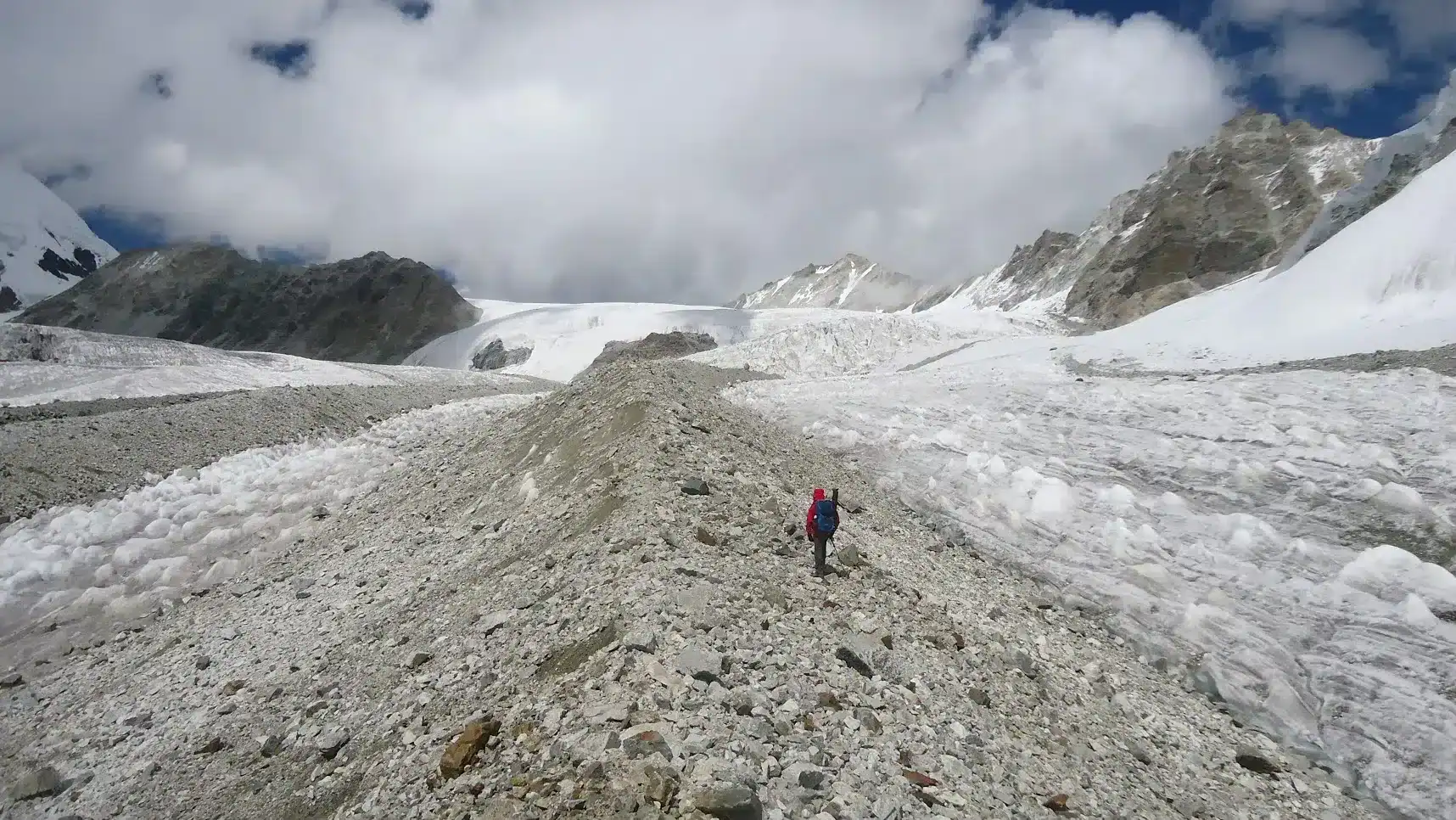
Today, we set out early for a trek of 6 kilometres from Sweta Glacier to Kalindi Base Camp, reaching an altitude of 18,569 feet. Though the distance isn’t long, the trail covers moraine terrain, so starting early gives us ample time to navigate safely.
On the way, we’ll witness the vibrant colours of Chaturanga Glacier, where shades of pink, yellow, brown, and green bring the landscape to life. This glacier also serves as a major tributary to the Gangotri Glacier, connecting us to a vast network of ice flows in the region.
Our campsite, Kalindi Bhamak, lies near the edge of Kalindi Glacier, surrounded by rugged natural beauty. Just up ahead is Kalindi Khal, a pass nestled between Avalanche Peak and Kalindi Peak.
Day 11: Trek from Kalindi Base Camp to Rajaparav via Kalindi Khal Pass
- Trek Distance: 13 km
- Starting Altitude: Kalindi Base Camp (18,569 feet / 5,660 meters)
- Pass Altitude: Kalindi Khal (19,488 feet / 5,940 meters)
- Arrival Altitude: Rajaparav (16,076 feet / 4,901 meters)
- Trek Duration: Approximately 8–10 hours
- Overnight: Camping at Rajaparav
Today is the most awaited day of the trek. The climb to Kalindi Khal Pass (19,488 feet / 5,940 meters) is challenging and requires a steady, determined pace. But once you reach the top, the views make every effort worthwhile.
From the pass, you’re treated to breathtaking sights of Mt. Kamet, Mt. Mana, Chandra Parbat, Vasuki Parbat, and, on clear days, even a glimpse of the Tibetan Plateau in the distance. After savouring the vistas, we descend to Rajaparav (16,076 feet / 4,901 meters), where we’ll set up camp amid the raw beauty of glacial terrain.
Day 12: Trek from Rajaparav to Arwa Tal
- Trek Distance: 13 km
- Starting Altitude: Rajaparav (16,076 feet / 4,901 meters)
- Arrival Altitude: Arwa Tal (14,763 feet / 4,500 meters)
- Trek Duration: Approximately 6–8 hours
- Overnight: Camping at Arwa Tal
Today, we trek over glacial terrain on a 13-kilometer route to Arwa Tal (14,763 feet / 4,500 meters). The path is challenging, with icy and rocky stretches, but the stunning scenery makes it all worthwhile. As we get closer to Arwa Tal, the remote landscape offers a peaceful sense of isolation, perfect for reflecting on the journey so far. Camping by this high-altitude lake is truly special, letting us experience the beauty of nature in its purest form.
Day 13: Trek from Arwa Tal to Ghastoli and drive to Badrinath
- Trek Distance: 12 km to Ghastoli + Drive to Badrinath
- Starting Altitude: Arwa Tal (14,763 feet / 4,500 meters)
- Arrival Altitude at Ghastoli: 12,467 feet / 3,800 meters
- Arrival Altitude at Badrinath: 9,842 feet / 3,000 meters
- Trek Duration: Approximately 5–6 hours
- Overnight: Lodge stay in Badrinath
The 12-kilometer trek today takes us across more glacial moraine as we move toward Ghastoli (12,467 feet / 3,800 meters). The landscape gradually shifts from rocky greys to vibrant greens as we near Ghastoli, a beautiful meadow that signals our approach to civilization. From Ghastoli, we board a vehicle for a scenic drive along the Mana Pass road that brings us to Badrinath (9,842 feet
/ 3,000 meters). Here, the familiar sight of lush valleys and rushing rivers is a comforting contrast to the stark beauty of the glacier we’ve left behind.
Day 14: Badrinath to Dehradun
- Drive Distance: 295 km
- Starting Point: Badrinath (9,842 feet / 3,000 meters)
- Arrival: Dehradun
- Highlights: Scenic drive along the Alaknanda River, river confluence at Devprayag
- Travel Duration: Approximately 10–12 hours
On the last day, we board a vehicle to drive back to Dehradun, which covers approximately 295 kilometres. The route follows the Alaknanda River, joining the Ganges at Devprayag, where the two rivers merge. This drive is a reflective end to the trek, with stunning views of the river valley and the rolling hills.
We’ve prepared a comprehensive Trek Route Map for your upcoming adventure to Kalindi Khal Pass Trek, which outlines the entire journey including all stops and trails. This map provides detailed information on the terrain, distance between points of interest, and estimated travel time to help ensure a safe and enjoyable trek. We’ve carefully curated the map to ensure that you have all the necessary information at your fingertips. Please take a moment to review it thoroughly, and don’t hesitate to reach out if you have any questions or concerns.
The Trek Altitude Chart is a useful tool for Trekkers to monitor their altitude changes during their rides, allowing them to plan their routes more efficiently and track their progress over time. This Kalindi Khal Trek chart is beneficial for both casual and experienced Trekkers, helping them make the most out of their Trek experience.
Trek Cost Inclusions
- Stay: 11 Nights of tented accommodation at individual campsites of Trekup India on twin sharing.
- Meals: Trekup India will provide freshly cooked meals during the trek starting with Lunch on Day 1 to Lunch on day 14 (Meals are simple, nutritious, and vegetarian)
- Transport: Manali to Jobra and return.
- Trek Insurance (Optional): Trekup India recommends that all trekkers consider getting trek insurance. This is optional, but highly recommended. Trek insurance covers unexpected events that may occur during your trek. The cost of the insurance starts from INR 210. Please read more about what is included in the coverage and why it is mandatory on treks.
- Trek Equipment: Sleeping bag, Sleeping tents, Kitchen tent, Dining tent, Toilet Tent.
- Amenities: All utensils, sleeping mattresses (Black foam mats), Crampons, and Gaiters for snow.
- Health & Safety: First Aid Box, Oxygen Cylinders, Stretchers, Oxi meters, BP Machines, health.
- Permits: Forest Permits and Camping Permission Fee
- Trek Crew: High Altitude Chef, Helpers, Trek Leader & Guides, and other support teams.
- Potters & Mules: Potters and Mules are to carry all trekking equipment, ration, and vegetables.
Trek Cost Exclusions
- GST 5% (it is Mandatory)
- Any Meals/accommodation beside the itinerary or not mentioned in the program.
- Any Bus / Airfare to/from trek start/end point
- Personal Medical expenses do carry your medication.
- Any personal services such as Laundry, phone calls, liquors, mineral water, etc.
- Any still / video camera fee
- Any Entrance fee Monuments, Monasteries, Museums, Temples – Pay directly on the spot.
- Mules or porter charges to carry private baggage (Offload Charges for bag 15000 for whole trek, if paid online (at base camp 20,000). Note: Bag weight should not be more than 10 kg.
- Any emergency evacuation charges
- Any services that are not mentioned in the cost inclusion section.
What should you pack for the Kalindi Khal Trek
Kalindi Khal Trek is a high-altitude trek. The trekking gear you have to have for this particular trek differs from normal treks. Thus, read this whole segment. There is an important question that the trekker who is doing trek asks, like what all things to carry while trekking. Below, we have provided the details on everything you should take; an easy way to remember is by Head to foot or foot to head. We have prepared from Head to foot.

Head Gears
When trekking it's important to carry headgear to protect your head and face.
Heading out for a trek? Don’t forget to carry headgear to protect your beautiful face and head from the sun, wind, and dust! It’s an essential accessory that keeps you safe and comfortable throughout your adventurous journey. So, make sure you pack it before you step out into nature!
- Head Lamps – When trekking at night, headlamps are essential to illuminate your path while keeping your hands free. Headlamps come in different sizes and lumens, so it is essential to choose one that suits your needs.
- Hats or Cap – Caps or hats are also necessary when trekking in different weather conditions. Caps protect your head from the wind and freezing temperatures at night, while hats provide shade and protection from the sun during the day. It’s essential to ensure that your hat has a strap to prevent it from being blown away by the wind.
- Sunglasses – Sunglasses are also essential for trekking. Your sunglasses should protect your eyes from harmful UV rays and fit your face perfectly to avoid falling off while climbing, jumping, or crossing obstacles. The glass of your sunglasses should also be designed for different weather conditions to provide optimal visibility.
- Buff / Balaclava – Lastly, a buff or balaclava is a must-have to protect your mouth or neck from extreme temperatures and keep them warm. Buffs and balaclavas come in different materials, thicknesses, and designs, so it’s important to choose one that suits your needs and preferences. Depending on the weather conditions and your activities, you can wear them as neck warmers, face masks, or headbands.
Clothes
When trekking in high altitudes, prepare for cold weather by wearing layers. Layering traps heat, keeps you warm, and allows you to easily adjust your clothing as temperatures fluctuate.
Layering is important for different seasons when trekking. When planning a high-altitude trek, it is important to prepare for the cold weather. Wearing layers is the best approach as it provides both protection and flexibility when the weather changes frequently in the mountains. Layering helps to trap heat and keep your body warm, while at the same time allowing you to easily adjust your clothing as the temperature fluctuates. By wearing layers, you can enjoy your trek comfortably and stay safe in the unpredictable mountain weather
- For spring, summer, and monsoon treks, consider wearing three layers: a woollen sweater, a fleece, and a padded jacket.
- For autumn treks, add one more fleece layer to make it four layers.
- For winter treks, you may need five layers with thermals, a woollen sweater, two fleeces, and a padded jacket.
- T-shirt/sleeve shirt– Bring three T-shirts and two quick-dry trek pants, wearing one and carrying the others. Long sleeve shirts help to protect from sun UV rays. We recommend synthetic T-shirts as they get dry quickly when they get wet.
- Hiking / Trekking Jacket– down jackets (-5 to-10 C) or two-three-layer jackets.
- Thermals– at least two pairs of thermals help keep the body warm during cold weather.
- Undergarments– you can carry them according to your habitual and hygiene requirements.
- Gloves– 1 pair of gloves will keep your hand warm and nice.
- Trek Pants– Bring 2 to 3 comfortable trekking pants. Trekking pants play a significant role, as they are designed for comfort and mobility, making trekking easier. It should be Synthetic so that it gets dry quickly when wet.
- Rain Wear– you can carry a raincoat or Poncho. During long rains and snowfalls, the waterproof jackets start leaking. Still, the Poncho and raincoats keep you dry, so choose accordingly.
Tip: If you choose a raincoat on your trek, carry a small waterproof cover so things inside your backpack can’t get wet. If you carry a Poncho, you don’t need to worry. It protects both you and your backpack.
Foot Gears
When it comes to planning a trek, one of the most important aspects is to ensure that you have the right kind of foot gear.
- Trekking shoes which are waterproof and have ankle support. Walking / Hiking sandals which can be used off the trek, i.e., in the morning and evening hours when you reach the campsite, basically to get your feet rest from heavy boots, sometimes used for crossing streams and rivers, it’s more comfortable and safer than crossing barefoot or wetting your shoes. Sneakers (Optional) can be worn for normal driving days or used around the camp.
- Socks– you should at least carry 3 to 4 pairs.
- Microspikes & Gaitorswill be provided by Trekup India when required. You don’t have to carry them.
Personal First Aid Kit
Don't forget to pack your personal first aid kit! It's always better to be safe. So, make sure you're prepared for any unforeseen circumstances.
Below are some common medicines generally required/used during your adventure trip; however, please consult your doctors prior.
- Antiseptic towel or water syringe (to clean the wound)
- Butterfly bandage for a small cut
- Cotton and elastic bandages and sterile gauze pad for larger wounds
- Latex gloves are used when the wound bleeds.
- Medicine for Diarrhea (Upset stomach)
- Medicine for cold, flue/fever, headache
- Some pain killers
- ORS pouches
- Quick pain relief spray (External use)
- Any personal medicine prescribed by your doctor
- Dimox / Similar for high altitude sickness
- Bug Repellent
- Carry some nutria/energy bars and drinks (non-alcoholic)
- Note: Kindly consult your doctor before purchasing or taking any medicine.
Gadgets and Other Items
You might also consider bringing a camera, binoculars, portable charger, and snacks. Be well-prepared and tackle any trail with confidence.
- Trekking Poles
- Mobile phone
- Camera
- Spare batteries for phone and camera, power bank
- Lightweight flashlight or headlight
- A waterproof bag made of plastic is used for the camera.
- Plug/converter for electrical items
- 1-litre water bottle
- A journal with a pen would be a good idea to keep your notes.
- Some book of your interest for the ideal time
- Get into the habit of maintaining a Map and guidebook of the region.
Hygiene & Personal toiletry
Remember to pack hygiene and personal toiletry items such as soap, shampoo, toothbrush, toothpaste, deodorant, and toilet paper.
- Sunscreen with UV protection to shield your skin from harmful rays
- 1 or 2 small quick-drying towels to help you dry off quickly in case of rain or sweat
- Toilet paper, tissues or wet wipes for maintaining hygiene while on the trek
- Toothbrush, toothpaste, and mouth freshener to keep your mouth clean and fresh throughout the journey
- Deodorant or talcum powder to help you stay fresh and odor-free, especially during hot and humid climates
- Shampoo to keep your hair clean and healthy
- Sanitary pads or tampons (for female trekkers) to manage menstrual cycles
- Lip-gloss or salve to protect your lips from dryness and chapping
- Bio-degradable soap to keep yourself clean and hygienic while on the trek
- Nail clipper and other personal items that you use daily
Compulsory Documents to Carry
There are certain documents that you should always carry with you. These documents are not only necessary for your safety and security, but they may also be required by local authorities.
These files must be submitted to the Forest Department before your trek. With none of these, you will not be permitted to trek—original and photocopy of government photo identity card. Carry IDs like Aadhaar, voter ID, etc.
How To Plan Your Trek & Reach Gangotri, Uttarakhand?
It’s important to note that all participants must reach Manali at the start of the program. To cater to your travel preferences, we offer three options:
Option 1: Consider traveling overnight on a government bus to Manali. The journey takes 14 hours from Delhi and 10 hours from Chandigarh. We strongly recommend government buses over private ones, as they are more reliable and less likely to be delayed. Regardless of your choice, aim to reach Manali between 9 and 10 am.
Option 2: If you prefer to fly, the best option is to fly to Delhi or Chandigarh airport, then take a bus to Manali. Another alternative is to fly to Bhuntar Airport, which is only two hours away from Manali. However, we advise against this due to the high flight costs and potential for cancellations. If you do choose to fly to Bhuntar, ensure you arrive at least a day before the trek begins.
Option 3: It is possible to go by train. Pathankot railway station, from where you can take bus services that direct you to Manali which is about 300 kilometers from the station and will require an overnight trip. If you choose this option, it is best to arrive one day prior to Manali.
Rest assured, when you arrive at the trek assembly point in Manali, Trekup India will take care of your journey to Jobra, Chatru, and back to Manali, including an excursion to Chandratal. Please ensure you reach Manali before 10:30 am on the first day of the program to allow for a timely departure to the assembly point.
Fitness Required & Preparation Guide For Kalindi Khal Trek
If you’re preparing for a Kalindi Khal Trek, Trekup India recommends jogging as part of your fitness routine. Jogging helps work out the same muscle groups that you’ll use during trekking and can help you build endurance. You don’t need any special equipment to get started.

Fitness Target
Trekup India has put the Kalindi Khal Trek into an easy-to-moderate-grade-level trek.
For Easy – Moderate Treks – In order to be well-prepared for your upcoming trek, it is recommended that you focus on building your endurance by aiming to cover a distance of 4.5 kilometers in less than 45 minutes. This will help you to develop the necessary stamina and strength required to successfully complete your journey.
How to Achieve This Fitness Target?
To start preparing for your trek:
- Try jogging for at least five days every week.
- If you find 4.5 km too difficult at first, begin with 2 km and gradually increase over 2-3 weeks.
- Once you feel more comfortable running 4.5 km, focus on improving your speed gradually on a daily basis.
It is important to ensure that you can consistently complete 4.5 km in under 45 minutes for at least two weeks before your planned trek. Allow yourself 6-8 weeks to prepare physically for the journey.
Strength Training exercises that benefit Trekking
Trekking is an activity that demands a good level of strength.

Trekking is a demanding activity that requires good cardiovascular endurance, muscular strength, and overall fitness. To help you prepare for your trek, incorporating bodyweight exercises into your training routine can be an effective way to build strength, improve stability, and enhance endurance, all of which are crucial for a successful trek. In this regard, here’s a breakdown of body weight exercises categorized by the specific body parts they target and the benefits they offer during trekking.
1. Lower Body Exercises
Lower body exercises like squats and lunges are great for building lower body strength, essential for trekking.
a. Squats
Squats are an excellent exercise for building lower body strength, essential for trekking. They target the quadriceps, hamstrings, glutes, and calves. Solid quadriceps and glutes provide power for ascending and tackling uphill climbs, while vital hamstrings aid stability during descents. This is particularly helpful in navigating uneven terrain during trekking.
How to perform Squats Exercises:
- Stand with feet shoulder-width apart, toes pointing slightly outward.
- Lower your body by bending your knees and hips, keeping your back straight.
- Lower until your thighs are parallel to the ground or as low as comfortable.
- Push through your heels to return to the starting position.
b. Lunges
Lunges target the quadriceps, hamstrings, glutes, and calves. They improve lower body strength, balance, and stability, crucial for maintaining control on rocky trails and steep slopes. Additionally, they enhance flexibility, reducing the risk of injury while trekking.
How to Perform Lunge Exercises:
- Stand with feet hip-width apart, hands on hips or sides.
- Take a step forward with one foot, lowering your body until both knees are bent at 90-degree angles.
- Push through the heel of your front foot to return to the starting position.
- Repeat on the other side, alternating legs.
2. Upper Body Exercises
Upper body exercises such as push-ups and pull-ups effectively strengthen the upper body, especially the chest and shoulders, which are essential for carrying a backpack during treks.
a. Push-Ups
Targets: Chest, shoulders, triceps, and core.
Benefits for Trekking: Push-ups are an effective exercise to strengthen the upper body, especially the chest and shoulders, essential for carrying a backpack during treks. Improved upper body strength will also help maintain posture and stability while traversing challenging terrain.
How to Perform Push-Ups Exercises:
- Start in a plank position with hands shoulder-width apart and body in a straight line from head to heels.
- Lower your body by bending your elbows until your chest nearly touches the ground.
- Push through your palms to return to the starting position.
- Keep your core engaged throughout the movement.
b. Pull-Ups/Bodyweight Rows:
Targeting the back, biceps, and shoulders can significantly benefit trekking. You can strengthen these muscle groups by performing pull-ups or bodyweight rows and improve your posture and balance while carrying a backpack. Additionally, more muscular back muscles can help reduce the risk of back strain and fatigue during long treks, making your journey safer and more comfortable.
3. Core Exercises
Core exercises like planks and Russian twists can help strengthen the core muscles, which are crucial for maintaining stability and balance while trekking on uneven terrain.
a. Planks
Targets: Abdominals, obliques, and lower back.
Benefits for Trekking: Planks are an effective exercise that helps strengthen the core muscles. These muscles are crucial for maintaining stability and balance while trekking on uneven terrain. A strong core also helps improve posture, reducing the risk of back pain and fatigue during extended hikes.
How to Perform Planks Exercises:
- Start in a plank position with elbows directly under shoulders and body in a straight line from head to heels.
- Engage your core and hold the position, avoiding sagging or arching the back.
- Keep breathing steadily and hold for the desired duration.
b. Russian Twists
Targets: Obliques, abdominals, and lower back.
Benefits for Trekking: Russian twists engage the core muscles, particularly the obliques, improving rotational stability and balance. Enhanced core strength helps prevent injuries and improves overall performance during trekking.
How to Perform Russian Twist Exercises:
- Sit on the ground with knees bent and feet flat, leaning back slightly to engage the core.
- Clasp hands together and twist the torso to one side, bringing the hands towards the ground beside the hip.
- Return to the centre, then twist to the other side.
- Continue alternating sides for the desired number of repetitions.
4. Full Body/Cardiovascular Exercises
Full-body/cardiovascular exercises like burpees and mountain climbers are excellent for improving cardiovascular endurance, strength, and agility.
a.Burpees
Burpees are an excellent full-body exercise that targets your legs, chest, arms, and core. This exercise dramatically benefits trekking enthusiasts, improving cardiovascular endurance, strength, and agility. Regularly incorporating burpees into your workout routine can enhance your overall fitness level, which can help you endure long hikes and rugged terrains with ease.
How to Perform Burpees Exercises:
- Start in a standing position.
- Squat down and place hands on the ground.
- Jump feet back into a plank position.
- Perform a push-up.
- Jump feet back to the squat position.
- Explosively jump up into the air, reaching overhead.
- Land softly and repeat the sequence.
b. Mountain Climbers
Mountain climbers target the core, shoulders, chest, and legs. This dynamic, full-body exercise can significantly improve cardiovascular endurance and agility. It is an excellent functional workout for trekking preparation as it engages both the upper and lower body muscles while strengthening the core muscles.
How to Perform Mountain Climbers Exercises:
- Start in a plank position with hands shoulder-width apart and body in a straight line from head to heels.
- Drive one knee towards the chest, then quickly switch legs, alternating in a running motion.
- Keep the core engaged and the hips stable throughout the movement.
- Continue at a moderate to fast pace for the desired duration.
Incorporating bodyweight exercises into your training routine can help you build strength and endurance and prepare your body for the physical demands of trekking. Consistency and proper form are crucial to maximizing the benefits of these exercises and ensuring a safe and enjoyable trekking experience. Engaging your core muscles, including obliques, abdominals, and lower back, with Russian twists can improve your rotational stability and balance, preventing injuries and enhancing overall performance during trekking.
When incorporating strength training exercises into your workout routine, it’s essential to maintain proper form and technique to avoid injury. Start with lighter weights and gradually increase the intensity as you progress, focusing on compound exercises targeting multiple muscle groups simultaneously. Some examples of practical strength training exercises for trekking include squats, lunges, deadlifts, and pull-ups.
Remember to give your muscles time to recover between workouts, and remember to stretch before and after your workouts to prevent injury and improve flexibility. Combining strength training with jogging and proper stretching allows you to take your fitness to the next level and confidently tackle even the most challenging treks.
Our Trekkers Reviews And Expreinces


We provide only Indian vegetarian food, and your meal will mainly consist of Indian bread, vegetables, lentils, rice, and a delicious dessert. During your trek, we will serve three meals a day, including breakfast, lunch, and dinner. You will also be served tea, snacks, and lip-smacking soup in the evening before dinner. If it is a long day of trekking, you will be given a packed snack.
After extensive research on the trekkers’ nutritional requirements, we prepare the menu. Before putting all the meals together, we also consider the altitude and the weather.
The meal we serve during the trek is perfectly balanced with calories, carbohydrates, vitamins, protein, fibre, and minerals. You need to know that all our cooks have great expertise in cooking and have undergone thorough training. So, get ready to enjoy delectable and lip-smacking dishes during your trek. You will be served with lemon tea in the tent to start your day with a refreshed feeling. Before leaving the campsite for trekking, you will be given a hot finger-licking breakfast like upma, Aallu Prantha, Besan Chilla, Poha, Daliya, Corn flakes, and Maggie, along with tea or coffee.
If your trek is longer, we also offer some fresh local fruits such as apples and healthy drinks like Frootie or Maaza. In the afternoon, you will be served a simple & healthy lunch, while at around 04:00 pm, you will be given tea and a light evening breakfast. After you reach your campsite at night, you will be served a hot and delightful dinner.
After reading this, you must have understood the food we provided on the trek; you don’t need to worry about food. Many trekkers repeatedly trek with us because of the food we provide. Thus, we will give you unforgettable experiences.

Trekking with us for the Kalindi Khal Trek is entirely safe because we have a team of trek leaders qualified in Wilderness first-aid and complete information about the high-altitude glitches. During the trek, we carry a full first-aid kit that contains all the essential medicines. Before trekking with us, you must ensure that you are medically fit for the trek; for us, your medical fitness is more important than anything else.
Right from our establishment, we at Trekup India have been continuously introducing new safety practices into Indian trekking to ensure the safety of voyagers. Trekup India introduced microspikes and made emergency bottled oxygen mandatory for all treks. Our trek leaders take your daily Pulse oximeter reading. We at Trekup India introduced the radio walkie-talkie as a safety communication device.
How can we ensure that your trek is safe with us?
We have noticed that most trek-organizing organizations do not follow these systems, but with time, they are following us; several competing companies are adopting these practices and organizing great, safe treks.
We ensure complete technical safety in the mountain. Our company has a vast team of more than 100 guides and trek leaders who serve on Himalayan treks. One of the best things about our team is that all the members are trained professionally by the Nehru Institute of Mountaineering, Indian Mountaineering Foundation Delhi, and Hanifle Center Outdoor Education Mussoorie.
Explore our New Safety Protocols
To ensure a perfect Trek, we have introduced some new safety checks to ensure excellent safety for our trekkers.
Our On-trek safety checks include:
- Daily oxygen saturation, along with pulse readings
- Stretchers team appointed on every trek
- Radios
- Trained mountain staff and complete safety
- Additional oxygen cylinders
- Special medical kit for high-altitude treks
- Microspikes on all types of snow treks
- Experienced Trek leaders, as well as safety
- Technical team on all snowy slopes
For Us, Your Safety Is the Top Priority
At Trekup India, you will find a team with local knowledge and fluency in English and Hindi. This helps ensure that you have a fantastic trek. Not only this, but we also pay attention to your health and safety because this is something we cannot ignore. All the team leaders involved in trekking have already undergone several professional courses in first aid, portable altitude chamber training, CPR, environmental awareness training, and advanced wilderness emergency medicine.
We also carry a complete first aid medical kit on every trek and trip we organize. Apart from the medical kit, we take a portable altitude chamber (if needed) and medical oxygen for all high-altitude treks. Our company has significant expertise in organizing all sorts of group adventure holidays for family groups, school and college groups, and friend groups. We have many travel options that suit different fitness levels and travelling styles.
Regardless of the group size, we value each and every member of our trekking groups. Our commitment to personal attention ensures that your needs and safety are always our top priority.
Who we are?
Trekup India has been a stalwart in the Adventure Tourism industry for 30 years. Since our inception, we have been dedicated to providing top-notch treks, voyages, trekking programs, and high-altitude expeditions. Our extensive experience is a testament to our commitment to your adventure and safety.
We organize treks in Uttarakhand, Kashmir, Sikkim, and Himachal while being part of the trekking community; we feature more than 75 documented Himalayan treks. In addition to other outdoor activities, our company also organizes trips for schools, colleges, and families.
Therefore, we maintain the quality of services offered to our valuable customers.
Must Read These Information Of Kalindi Khal Trek
Why You Should Do Kalindi Khal Trek?
…
Best time to do Kalindi Khal Trek
The best time to embark on the Kalindi Khal Trek is from May to June and then again in September and October. These months offer the most favourable conditions, with clear skies and stable weather that make high-altitude trekking safer and more enjoyable.
During May and June, trekkers can witness the snow beginning to melt, revealing lush valleys and vibrant meadows along the route.
The autumn months, September and October, bring cool, crisp air and stunning visibility of the surrounding peaks. However, the terrain remains rugged and unpredictable even during these optimal windows, making the trek ideal for experienced adventurers who can navigate high-altitude challenges.
For those seeking a rewarding journey through the heart of the Garhwal Himalayas, planning a trek during these months ensures the most immersive and awe-inspiring experience.
How Difficult is the Kalindi Khal Trek
We don’t recommend Kalindi Khal to beginners as the journey is challenging, with rugged terrain and unpredictable weather, and tests your endurance. But for those prepared, it’s a life-changing adventure. Trekking through the untouched beauty of Kalindi Khal leaves you with a sense of awe and a deeper connection to the Himalayas.
The Kalindi Khal Pass Trek awaits if you’re drawn to adventure, nature, and high-altitude treks in India. This is more than a trek; it’s a transformative experience.
Frequently Asked Questions About Kalindi Khal Trek
Is Prior Trekking Experience Necessary for the Kalindi Khal Trek?
Prior trekking experience is required.


