
Trek Grade
Moderate to Difficult
Highest Altitude
15,100 ft
Base Camp
Yuksom
Best Time
April, May & Sept, Oct
Trek Distance
87 Km
Not sure which trek is right for you? Trekup India’s Mountain Experts have you covered.
Not sure which trek is right for you? Trekup India’s Mountain Experts have you covered. From figuring out if a trek matches your fitness level to knowing who you’ll be trekking with, we’re here to answer all your questions. Reach out to our Mountain Experts and plan your trek with confidence.
Goechala Trek
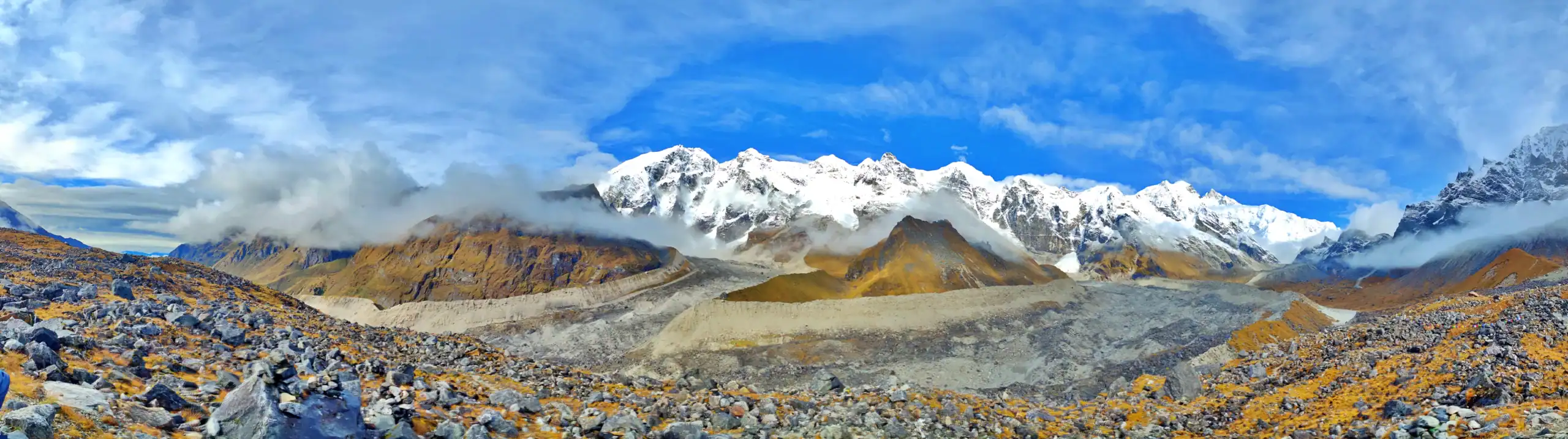
The Goechala Trek, a thrilling adventure for trekking enthusiasts, offers a stunning landscape and diverse weather conditions. Starting and ending in Yuksom, the capital of Sikkim, this trek provides breathtaking views of the Himalayas, including the majestic Kanchenjunga and the beautiful Goecha Lake. The trail, filled with exciting challenges, passes through lush forests, meadows, and streams, offering a mesmerizing experience for nature lovers.
Located within Sikkim, the Goechala Trek is a popular destination for Indian trekkers. It showcases unparalleled natural beauty that leaves you in awe. It includes lush valleys, orchards, diverse wildlife, and enchanting forests, making it one of the most beautiful treks in India. The journey begins from Darjeeling, adding to the unique charm of this trek.
Sunrise over the Kanchenjunga Range is a highlight of the trek. It offers a breathtaking spectacle, especially for avid photographers. The best time to capture this awe-inspiring sight is early morning when the mountain range is most stunning.
The route is adorned with dense Rhododendron forests, vibrant with spring blooms and colourful flowers in summer. Trekkers can enjoy picturesque views of Samiti Lake, crystal-clear waters reflecting the majestic Mount Pandim, and the thrill of crossing suspension bridges over deep gorges.
The trek also includes a visit to the monastic complex of Tsokha, which offers stunning views of the Himalayas, especially during the rhododendron blooming season in spring.
The Goechala Trek is an 11-day adventure spanning 90 km, offering breathtaking views of the Himalayas. The trek starts from Yuksom and passes through Dzongri via Phedang, then through Thangshing before reaching Goechala. The journey includes scenic views through forests, a chance to see mountain animals like the Yak, and traversing diverse landscapes such as suspension bridges, monasteries, and vibrant Rhododendron meadows.
The trek requires good physical fitness, especially during the 9 km rocky trail reaching an altitude of 12,900 ft to Dzongri. The ascent from Lamuney to the Goechala Summit is challenging and demands physical endurance. The trek also offers a unique and thrilling experience with its high-altitude mountain pass providing a stunning panoramic view of Mt. Kanchenjunga’s southeastern face.
The Goechala Trek is not easily accessible and is best suited for experienced trekkers with a strong physical foundation. Thorough physical preparation is essential to mitigate altitude-related issues, and trekkers should be prepared for unpredictable high-altitude weather conditions. The trek can be undertaken in spring and summer months offer more enjoyable temperatures, while the autumn season increase the demanding nature of the journey.
Overall, the Goechala Trek promises an unparalleled combination of breathtaking scenery and adrenaline-fueled adventure, leaving trekkers awestruck and inspired by the natural wonders of the world.
Trek Cost
- Stay will be on a twin-sharing basis in tents
- + 380 Trek Insurance (Mandatory)
- Discount Policy
- ₹ 2,500 Extra For Transport ( Optional ) You can pay directly to driver there
Pickup time 6:30 A.M from NJP, & will drop by 4 P.M on last day.
Fix Departure Dates
Goechala Trek Videos
kVideos by experts watch these videos to prepare well for a Successful Trek

Want To Trek Like Pro?
Basically, watch these videos if you want to trek the same way professional trekkers do and make your skills better. These videos contain useful tips and techniques to further improve your trekking skills itself. These videos actually help both new and experienced trekkers improve their trekking skills. These videos definitely provide useful tips that make your trek better. We are seeing that these videos by Trekup India experts will only help you make your trekking skills better.


Know Everything About Acute Mountain Sickness
Acute Mountain Sickness occurs when people trek to high altitudes above 8,000 feet. This condition itself develops further due to reduced oxygen levels at such heights. Basically, as you go higher up, the air pressure and oxygen levels decrease, which causes the same problem. Acute Mountain Sickness surely causes headache, nausea, vomiting, and dizziness in affected persons. Moreover, peoples also experience difficulty in sleeping during this condition. To avoid mountain sickness, you should actually trek up slowly to higher altitudes. To learn further about this condition itself, watch the videos by Trekup India.


Day Wise Detailed Itinerary of Goechala
Day 1: Drive From (NJP) New Jalpaiguri to Yuksom
- Altitude: New Jalpaiguri (NJP) Railway Station (374 ft / 114 meters), Yuksom (5840 ft / 1780 meters)
- Altitude Difference: 5466 ft / 1666 m
- Drive Distance: 150 km
- Drive Duration: approx. 8 hrs
- Stay: Overnight stay at the Guesthouse.
- Meal: Dinner
The beautiful journey to Goechala begins at New Jalpaiguri Station, where our representative will greet you at 10 a.m. The drive to Yuksom, which is approximately 150 km away, takes about 8 hours, but if there is no congestion, it will take around 7 hours.
Upon arrival in Yuksom, Sikkim’s historical capital, you will get a glimpse into the rich heritage and religious traditions of Sikkim. To ensure safety and have official records of the trek, the first step is to obtain permission from Melli’s police station. You will need to provide basic information and attach two passport-sized photographs. Foreign nationals must get an Inner Line Permit (ILP) to continue their journey. The drivers will assist in obtaining the ILP, which should take no more than 30 minutes to complete.
After passing through Melli, located at the border between Melli and West Bengal, the next stop is Jorthang, where you can enjoy delicious northeastern cuisine. The journey then continues to Yuksom, which should be reached in the evening. Legship is the last ATM stop for those who need to withdraw money.
Once you reach Yuksom, you can rest at the guesthouse. In the evening, the tour guide will provide a brief overview of the trek, including the route, rules, and any environmental conditions. Please inform the tour guide if you have any medical conditions. Yuksom is also the final destination for picking up small meals or any other supplies needed during the trek.
According to the Sikkim government, foreigners (including OCI, NRI, and OCI) must obtain a permit to trek in Sikkim. Foreigners must arrive in Yuksom one day before receiving this permit. The ILP must be signed upon arrival in Sikkim, and the permit fees will cost Rs. 2,000 per person. Trekup India will assist you in obtaining the permit upon your arrival. Please note that the cost of an additional day is not included in our trek fees.
It’s important to note that citizens of Bangladesh, Myanmar, or China are not allowed to trek in Sikkim.
Day 2: Trek From Yuksom to Bakhim or Sachen
- Altitude: Yuksom (5840 ft / 1780 mtr), Sachen (7200 ft / 2196 mtr)
- Altitude Difference: 1360 ft / 416 m
- Trek Distance: 8 km
- Trek Duration: approx. 6 hrs
- Stay: Overnight stay at the campsite.
- Meal: Breakfast, Lunch, and Dinner
- Trek Grade: Gradual
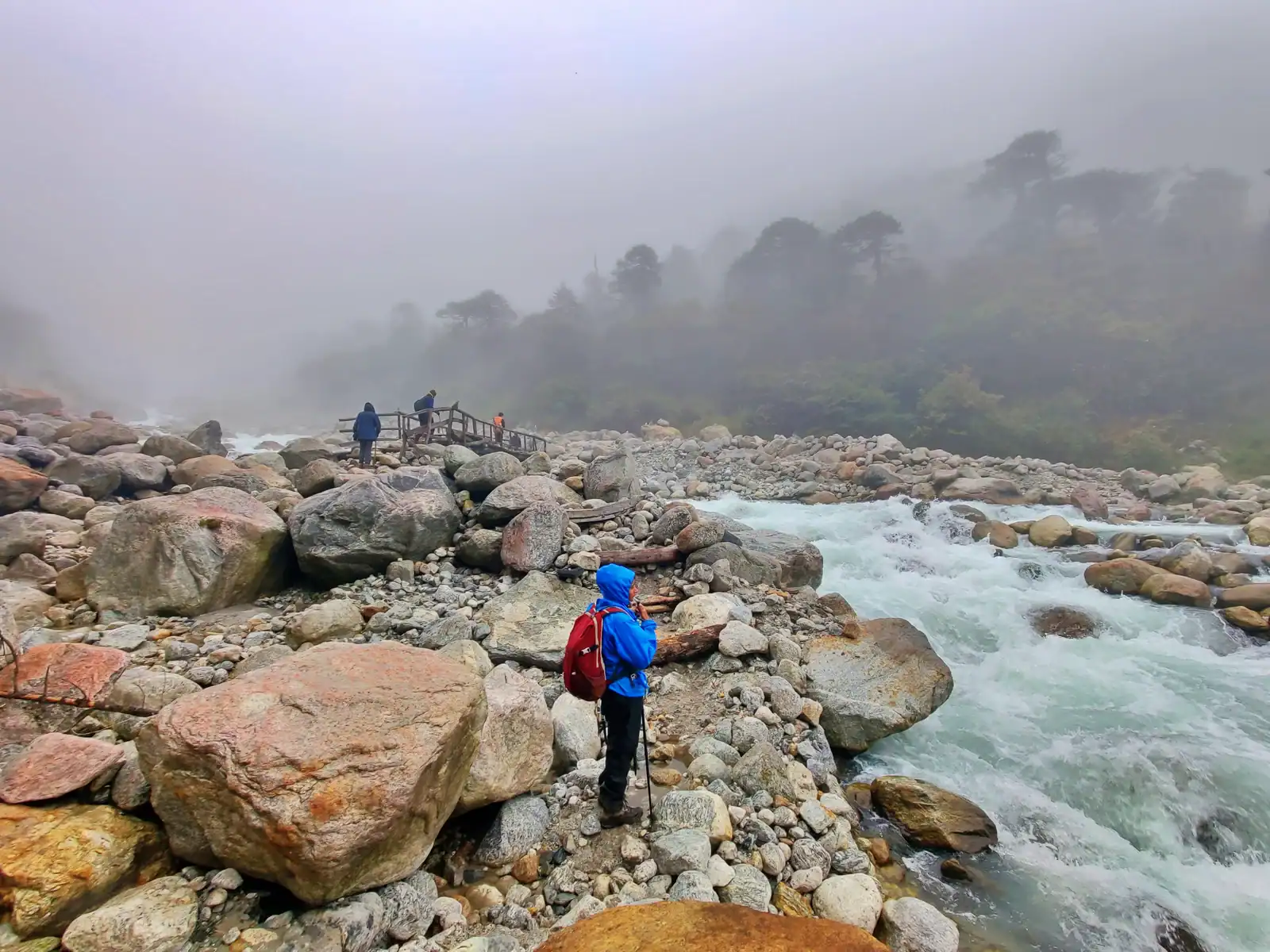
It takes about half an hour to reach the Pha Khola bridge. From there, the forest is thick and cool. Gradually, the trail gently climbs. Although the trail passes through the forest fringes, it is still exposed for approximately half an hour. Look to your right for shelter halfway through the exposed trail.
Continuing your journey through the humid jungle, you are suddenly greeted by a breathtaking sight. The Tshushay Khola waterfalls, a series of mini waterfalls that join the Prek below, cascade down in a mesmerizing display of nature’s beauty. A large iron bridge crosses the Tshushay Kohola 50 meters later, marking the start of a more noticeable climb on the trail.
An hour later, you will see another small cement bridge crossing the Mentogang Khola (you won’t find a sign telling you its name). It is already 7,100 feet, and you are only 20 minutes away from the Log Hut of Sachen.
At 7,200 feet, there is a small clearing with a single log house and shelter. A few meters below the trail is the log hut. There is enough space for approximately 6-7 people and an area to cook. The clearing is located just above the shelter if you have a larger group. Although it is not visible from the campsite, you can hear the Prek rushing down below.
Day 3: Hiking From Sachen to Tshokha
- Altitude: Sachen (7200 ft / 2196 meters), Bakhim (8650 ft / 2650 meters), Tshokha (9750 ft / 3000 meters)
- Altitude Difference: Sachin to Bakhim (1450 ft / 454 meters), Bakhim to Tshokha (1100 ft / 350 meters)
- Trek Distance: 7 km
- Trek Duration: approx. 5 hrs
- Stay: Overnight stay at the campsite.
- Meal: Breakfast, Lunch, and Dinner
- Trek Grade: Gradual
Enjoy the clear, crisp morning and prepare for the journey to Tshokha at 9,700 feet via Bakhim at an elevation of 8,600 feet. Although the trek is only 7 kilometres, it can take 7 hours. The height increases from this point, making hiking more difficult. The day’s hiking route will take you through forested areas towards Bakhim, where you will find beautiful magnolias and rhododendrons.
The next iron bridge over River Perk can be reached by a short walk of about 1 kilometre. It is fascinating to see the sparkling waters of River Perk and then to take in the enchanting atmosphere. The bridge is where hikers will see the prayer flags waving, marking the start of the Goechala trail. You can feel the elevation gain as you move towards your destination. The steep climb through the oak forest to Bakhim continues after this point. The hikers can see Mount Tenzinkhay and Mount Pandim as they climb. This is where the trail becomes steeper, and the temperatures drop.
Soon, Bakhim will be the first destination of the day. Here you can arrange a short break. The forest rest house is where trekkers often stop for long rests to take in the stunning views of Yuksom Valley. After a tiring climb, there are many excellent snack and tea stalls. Bakhim is a superb place to refill your water.
The trek to Tsokha continues for 2 kilometres after you have had some rest. Next is a mixture of steep ascents, descents, and slopes. Trekkers can enjoy the views of the alpine berries and rhododendrons at 9,000 feet. The plateau of Tsokha can be seen, and it is the campsite for that day. Trekkers can stay in large wooden huts that hold at least twenty people. There are still flat plains that can be used for tent placement. It is a beautiful spot with stunning views of snow-clad Himalayan peaks, Pandim and Kanchenjunga dominating the view. Enjoy the peaceful beauty of the natural world and a restful night in the tents.
Day 4: Tshoka to Dzongri Through Phedang By Trekking
- Altitude: Tshokha (9750 ft / 3000 mtr), Phedang (12,100 ft / 3700 mtr), Dzongri (12,900 ft / 3950 mtr)
- Altitude Difference: Tshokha to Phedang (2350 ft / 700 mtr), Phedang to Dzongri (800 ft / 250 mtr)
- Trek Distance: 9 km
- Trek Duration: approx. 7 hrs
- Stay: Overnight stay at the campsite.
- Meal: Breakfast, Lunch, and Dinner
- Trek Grade: Gradual to Moderate
Start by climbing to the small pond leading to the monastery, then follow its trail. Tshoka, a hamlet below, is quickly reached by climbing. Red rhododendrons are everywhere, and the slope will be a fiery red if they are in bloom (May 1st/2nd Week). After a steep 30-minute climb, the trail becomes a gentle ascent.
The trail is paved with wooden logs and filled with rhododendrons, making it a joy to walk. It resembles a park with wooden benches on either side. Sometimes, mist filters through the rhododendron trees, adding to the trail’s charm. The trail climbs steadily, and trekkers can feel the altitude. After the log path, a stony track leads to Phedang in just 20 minutes.
Phedang, located at 13,000 feet, offers spectacular views of the snow-clad mountain ranges. The landscape features a log hut and wooden benches, making it a good spot to stop for lunch or a rest. At Phedang, the trail splits, with one path leading to Kockchurang. Water can be obtained from a spring slightly below the route to Kockchurang, just 10-15 minutes away on a lower path.
Continue following the trail to Dzongri, which crosses a clearing. Soon, the trail climbs along the slope, lined by dwarf rhododendrons. The views improve with every step, but be cautious of muddy patches, especially after heavy rain. The trail is a ridge climb, switching between opposite sides of the hill. In the distance, the Kabru and Pandim ranges come into view. The climb concludes at a shrine with many prayer flags at 13,080 feet, the highest point of the day’s trek.
After a short rest at the shrine, continue on the trail towards Dzongri. The trail continues to undulate, with the first snow patches covering the roots of dwarf rhododendrons.
The Dzongri trekkers’ hut suddenly appears at a bend in the trail. A gentle stream surrounds the hut, and there are many camping areas around Dzongri. The hut can accommodate 30 trekkers at once.
Trekkers who have climbed from Tshoka will find Dzongri a welcome sight. At 12,980 feet, Dzongri meadows may feel the altitude effects. Dzongri, primarily fields, is surrounded by the mighty peaks of the Kanchenjunga range. Every direction offers a snow peak to admire. Dzongri is a fantastic reward for most trekkers, and many choose to end their trek here and return to their starting point.
Day 5: Acclimatization & Rest Day At Dzongri ( Trek Dzongri Top )
- Altitude: Dzongri (12,900 ft / 3950 mtr)
- Stay: Overnight stay at the campsite.
- Meal: Breakfast, Lunch, and Dinner
The next day begins with an hour of trekking to the Dzongri top at 13675 feet. Today is a rest day, allowing all hikers to set up their campsite and enjoy a day of relaxation. This is especially important as the altitude gained the day before was very high, and it takes time for the body to acclimate to this height. The picturesque view from Dzongri is captivating and rejuvenating, allowing trekkers to relax and regain energy for the next day. Trekkers will find many Tibetan prayer flags fluttering in the wind throughout the area. The breathtaking view includes the Gigantic Himalayan snow peaks, with prominent peaks such as Kanchenjunga (8534m), Kabru (75353m), and Mount Pandim (66691m). Other stunning peaks visible include Narsing (6147m) and Koktang (5825m), as well as Frey Peak, Kumbakarana (637m), Jupono, Simro, and others. This area offers the chance to capture stunning scenes of the Himalayas and create lasting memories. Exploring the area is recommended over staying in a tent.
Day 6: Early Morning Trek From Dzongri To Thansing Through Kockchurang
- Altitude: Dzongri (12,900 ft / 3950 mtr), Kokcharang (12,000 ft / 3658 mtr), Thansing (12,900 ft / 3950 mtr)
- Altitude Difference: Dzongri to Kokcharang (900 ft / 292 mtr), Kokcharang to Thansing (900 ft / 292 mtr)
- Trek Distance: 10 km
- Trek Duration: approx. 7 hrs
- Stay: Overnight stay at the campsite.
- Meal: Breakfast, Lunch, and Dinner
- Trek Grade: Gradual to Moderate
Within half an hour, the slopes are once again covered with rhododendrons. The descent continues gently for over 2 hours, and then the rhododendron trees give way to a rhododendron forest. As you lose 500 feet, the decline becomes steeper. You can spot birds in the woods as you walk silently through the forest, seeing birds hidden in the greens and browns. Eventually, you will reach Kockchurang. From there, find a path through the forest that leads to the right, which will take you to Phedang.
Kokchurang has a trekking hut but no actual places to pitch tents. However, you can pitch 4-5 tents along the banks of the Prek Chu River, about 50m away from the trekker hut. This small but beautiful campsite offers a lovely experience, especially at night when the mist hangs over the river, and the fog envelops the tents, with the sound of the rapid river below.
The trekker hut in Kokchurang has two large halls that can accommodate 10-12 trekkers at a time. The central hall can be used as a cooking area. Enjoy the cool river breeze while spending time on the bridge, overlooking the icy blue water below and the rhododendron forests on the opposite bank, which bloom in June but can be seen all year round. The trail, approximately 2kms between Thansing and the bridge, must be paved. Midway, the forests disappear, and the landscape becomes barren and rocky.
Thansing, a large meadow at the end of this climb, has a disused trekker hut that marks the entrance to the field. Although the hut suits a kitchen, tents must be kept inside. You can set up as many tents as you like in the open meadow, right in front of Pandim and with the left wall facing Kanchenjunga. Nights can be pretty cold at Thansing.
Day 7: Thansing to Lamuney by Trek
- Altitude: Thansing (12,900 ft / 3950 mtr), Lamuney (13,600 ft / 4150 mtr)
- Altitude Difference: 700 ft / 200 mtr
- Trek Distance: 4 km
- Trek Duration: approx. 3 hrs
- Stay: Overnight stay at the campsite.
- Meal: Breakfast, Lunch, and Dinner
- Trek Grade: Gradual to Moderate
The trekking schedule for the next day includes hiking to Lamuney, which is located at 13,650 feet. The trek takes approximately two hours to reach the destination. It is a relaxing day, so the plan is to wake up at 8 a.m., have breakfast at 9 a.m., and depart at 10 a.m. The trek to Lamuney is easy and enjoyable, passing through meadows and overstretched pastures.
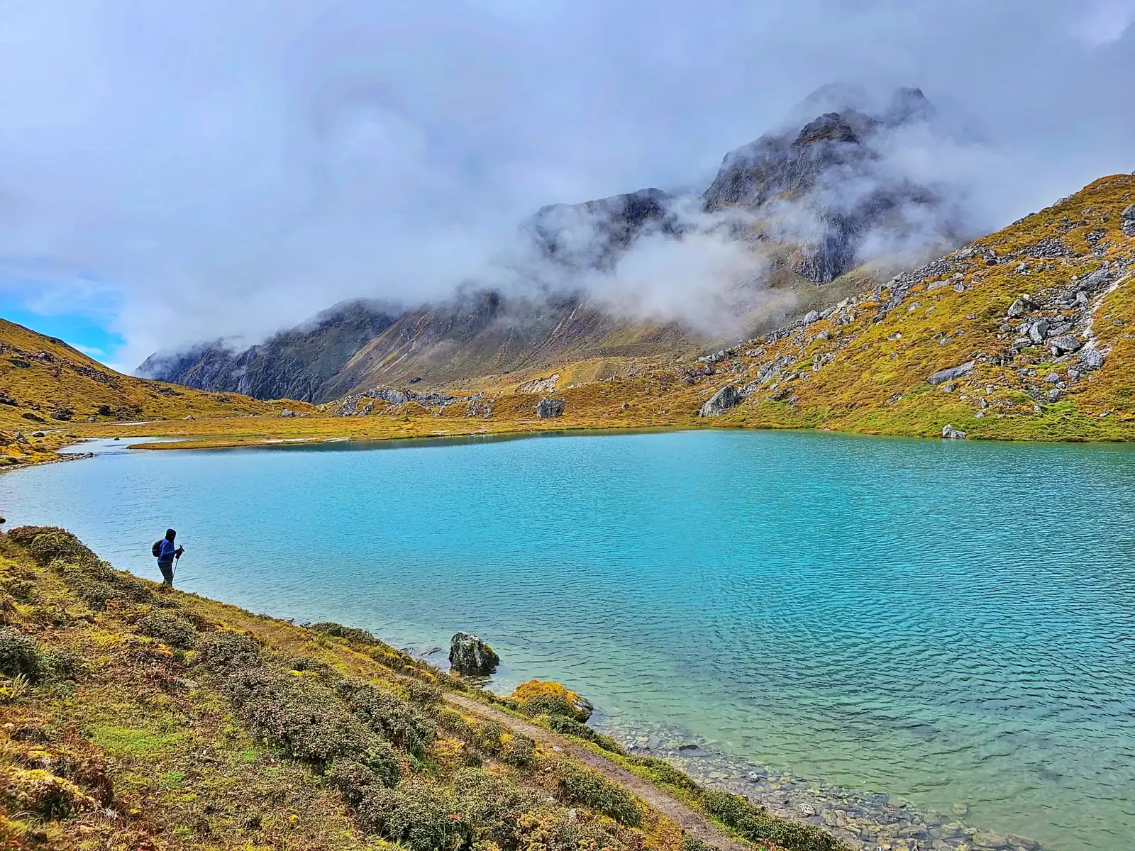
The trail to Lamuney is good, but there is a steep climb, so trekkers should be prepared. Hikers can enjoy a hot lunch in Lamuney and relax in the beautiful surroundings. The Samiti Lake, located just 2 km from the campsite, offers a stunning view. Although camping is not allowed near the lake, trekkers can enjoy its beauty before returning to the base. The uneven trail covered with pebbles and stones leads to the lake, which takes about an hour to traverse. The lake’s crystal clear waters and picturesque surroundings make it perfect for photography.
Before reaching the destination, the tour guide will brief you about what to expect at the campsite. Enjoy the clear night sky and the fantastic array of stars at such an elevation. Resting well and getting a good night’s sleep is best, as the next day will start early.
Day 8: Trek Starts Early Morning (1 A.M.) Lamuney to Goechala Through Samiti Lake back to Lamuney
- Altitude: Lamuney (13,600 ft / 4150 mtr), Samiti Lake (13,700 ft / 4200 mtr), Goechala (15,420 ft / 4700 mtr), Thansing (12,900 ft / 3950 mtr) / Kokchurang (12,000 ft / 3658 mtr)
- Altitude Difference: Lamuney to Samiti Lake (100 ft / 50 mtr), Samiti Lake to Goechala (1720 ft / 500 mtr), Goechala to Thansing (2520 ft / 750 mtr), Goechala to Kokchurang (3420 ft / 1042 mtr)
- Trek Distance: 18 km
- Trek Duration: approx. 13 hrs
- Stay: Overnight stay at the campsite.
- Meal: Breakfast, Lunch, and Dinner
- Trek Grade: Moderate to Difficult
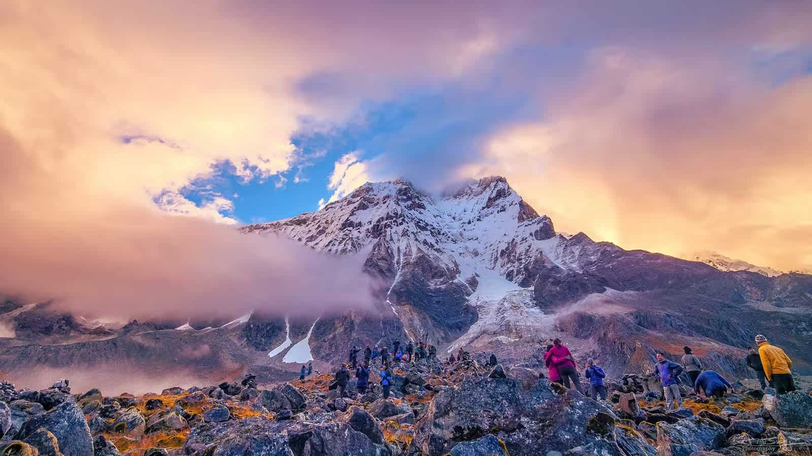
On the eighth day of the trek, hikers face the most challenging and longest stretch, covering 18 kilometres and approximately 13 hours. The day begins with a call to action at 1 AM, prompting trekkers to set out early for Goechala, located at 15,100 feet, and then return to Lamuney.
An early start allows ample time to ascend and descend and offers the opportunity to witness the stunning sunrise over the Himalayas. Packaging bags carefully for the return to the campsite in time for lunch is advised. Alternatively, trekkers can opt to visit Samiti Lake, which is about an hour away.
The climb to Goechala View Point, 15,100 feet and 5 kilometres from Lamuney, is steep and takes around 3 hours, depending on individual pace. Caution is advised as the route from Samiti Lake to the ridge is narrow and passes along the mountainside. The breathtaking view from the summit includes peaks such as Kabru South and Kabru North, Kabru Dome, and Kangchendzonga, with the morning sun casting a magical glow on the snowy mountains.
After taking in the panoramic vista, hikers should descend to Lamuney as soon as possible, enjoy a hot meal at the campsite, and then prepare to continue the descent to Thansing or Kokcharang. Descend as far as possible on the same day before choosing a campsite for the night. A rewarding rest at the tents in Thansing awaits after a day of challenging trekking.
Day 9:Trekking From Kokcharang / Thansing to Tsokha Through Phedang
- Altitude: Thansing (12,900 ft / 3950 mtr) / Kokchurang (12,000 ft / 3658 mtr), Phedang (12,100 ft / 3700 mtr), Tshokha (9750 ft / 3000 mtr)
- Altitude Difference: Thansing to Phedang (800 ft / 250 mtr), Kokchurang to Phedang (100 ft / 42 mtr), Phedang to Tshokha (2350 ft / 700 mtr)
- Trek Distance: 16 km
- Trek Duration: approx. 9 hrs
- Stay: Overnight stay at the campsite.
- Meal: Breakfast, Lunch, and Dinner
- Trek Grade: Gradual
You will descend from Thansing at 12,900 ft to Tsokha at 9,700 ft. The 16 km trek takes approximately 7 hours to complete. The day’s journey begins at 7 a.m., and it is best to reach the destination by 3–4 p.m. to avoid having to camp for too long. It’s recommended to pack a lunch.
The first destination, Phedang, takes approximately 4 to 5 hours. The return trail is straightforward and exciting without crossing Dzongri. The trail continues to the Rhododendron forest, which must be crossed to descend further. This forest is a beautiful place, vibrating with enthusiasm and new energy. It is easy to follow and has no steep stretches, making it pleasant. The best view on this trail is Mount Pandim, with its snow-covered peak rising out and glorifying it.
Although it is only five hours to Phedang, it can be tiring, so it’s best to rest once you reach Phedang. Trekkers have plenty of options for temporary camping spots where they can relax and enjoy their lunches in a relaxing atmosphere. The cool mountain breeze is very soothing and refreshing. You can enjoy the rich atmosphere and take some photos.
The trek to Tsokha continues on the same trail as the previous journey. The distance from Phedang to Tshoka is 5 km. As mentioned, the trail runs through forest lands and rich outgrowths of flora and fauna. It is easy terrain to descend, especially on steep slopes. It is best to take only a few breaks along the route to Tsokha before it gets dark. After reaching Tshoka, you can call it a night and set up your tents for a delicious hot dinner and a good night’s sleep. Getting as much sleep as possible the next day would be best.
Day 10: Trek From Tsokha to Yuksom Through Bakhim and Sachen
- Altitude: Tshokha (9750 ft / 3000 mtr), Bakhim (8650 ft / 2650 mtr), Sachen (7200 ft / 2196 mtr), Yuksom (5840 ft / 1780 mtr)
- Altitude Difference: Tshoka to Bakhim (1100 ft / 350 mtr), Bakhim to Sachen (1450 ft / 454 mtr), Sachen to Yuksom (1360 ft / 416 mtr)
- Trek Distance: 15 km
- Trek Duration: approx. 8 hrs
- Stay: Overnight stay at the campsite.
- Meal: Breakfast, Lunch, and Dinner
- Trek Grade: Gradual
The goal for today’s journey is to reach Yuksom, the starting point of our trek at 5,670 feet. It’s a 15km trek that takes about 7 hours to complete. We start early in the day, breathing in the fresh air and setting out with renewed energy. We bring packed lunch to save time on breaks as we descend. The path for the descent is the same as the one we took when climbing towards Goechala. The route offers stunning views of the snow-covered Himalayas and is filled with natural beauty. The trail is free of sharp turns, making the trek more accessible and enjoyable. We pass through popular places like Bakhim and Sachen, heading towards three iron bridges before reaching Yuksom. The stretch from Sachen onwards is less appealing due to its zig-zag design and constant changes in altitude.
The final part of the route involves climbing hillocks. Although it may be challenging after a day of physical exertion, it’s only a short distance. As we approach Yuksom, the telecom network is restored, allowing travellers to reconnect with loved ones. The town offers beautiful views of small, sloping villages, making it a pleasant return to Yuksom. Upon reaching the city, we can stay at a guesthouse, relax with a refreshing shower, enjoy a delicious meal, and get a restful night’s sleep. For those interested, there’s the option to explore the town in the evening, learn about the indigenous culture, and interact with the friendly locals. Travellers can also visit Sikkim monasteries to experience the local culture and explore the handicrafts in local stores. Remember to pick up some gifts for your loved ones and capture the memories of this fantastic trek with photos. This trek is genuinely one of the most beautiful in India.
Day 11: After Breakfast Yuksom to New Jalpaiguri Station by Drive
- Altitude: Yuksom (5840 ft / 1780 mtr), New Jalpaiguri (NJP) Railway Station (374 ft / 114 mtr)
- Altitude Difference: 5466 ft / 1666 mtr
- Drive Distance: 150 km
- Drive Duration: approx. 8 hrs
- Meal: Breakfast
- Trek Grade: By Road
The trek concludes the following day, and starting early is recommended due to the long drive ahead. You can enjoy the stunning sunrise from Yuksom in the morning, have breakfast, and begin the journey. Starting at 8 am, it is advisable to reach New Jalpaiguri station by evening. The total distance for the day is 150 km and will take around 8-9 hours, depending on road conditions and congestion. The return journey offers a scenic view of the Himalayas, and lunch is available in Jordan, with various eateries serving Chinese, Indian, continental, and local cuisines. After lunch, it’s best to head back early to reach the station on time.
If travel time is uncertain, travellers should arrange for an overnight stay at New Jalpaiguri and plan for an early departure. However, the expected arrival time at New Jalpaiguri is 5 pm. New Jalpaiguri is a prominent location within the Jalpaiguri district in West Bengal. If time permits, travellers can explore the famous Hong Kong Market (about 4 km from NJP station) and Bidhan Market (5 km from NJP station) and enjoy the local restaurants. Once the time is set, travellers can proceed with their onward journey.
Goechala Trek Route Map
We’ve prepared a comprehensive Trek Route Map for your upcoming adventure to Goechala Trek, which outlines the entire journey including all stops and trails. This map provides detailed information on the terrain, distance between points of interest, and estimated travel time to help ensure a safe and enjoyable trek. We’ve carefully curated the map to ensure that you have all the necessary information at your fingertips. Please take a moment to review it thoroughly, and don’t hesitate to reach out if you have any questions or concerns.
Goechala Trek Altitude Chart
The Trek Altitude Chart is a useful tool for Trekkers to monitor their altitude changes during their rides, allowing them to plan their routes more efficiently and track their progress over time. This Goechala Trek chart is beneficial for both casual and experienced Trekkers, helping them make the most out of their Trek experience.
Trek Cost Inclusions
- Stay: 9 Nights of tented accommodation at respective campsites of Trekup India on a sharing basis and 1 day in the guest house or hotel.
- Meals: Trekup India provided cooked meals during the trek, starting with Dinner on Day 01 to Breakfast on day 11 (Meals are simple, nutritious, and vegetarian and non-repeated meals)
- Transport: New Jalpaiguri (NJP) to Yuksom and Yuksom to New Jalpaiguri (NJP) on sharing jeeps
- Trek Insurance (Optional): Trekup India recommends that all trekkers consider getting trek insurance. This is optional, but highly recommended. Trek insurance covers unexpected events that may occur during your trek. The cost of the insurance starts from INR 210. Please read more about what is included in the coverage and why it is mandatory on treks.
- Trek Equipment: Sleeping bag, Sleeping tents, Kitchen tent, Dining tent, Toilet Tent.
- Amenities: All utensils, sleeping mattresses (Black foam mats), Crampons, and Gaiters for snow.
- Health & Safety: First Aid Box, Oxygen Cylinders, Stretchers, Oxi meters, BP Machines, health.
- Permits: Forest Permits and Camping Permission Fee
- Trek Crew: High Altitude Chef, Helpers, Trek Leader & Guides, and other support teams.
- Potters & Mules: Potters and Mules are to carry all trekking equipment, ration, and vegetables.
Trek Cost Exclusions
- GST 5% (it is Mandatory)
- Any Meals/accommodation beside the itinerary or not mentioned in the program.
- Any Bus / Airfare to/from trek start/end point
- Personal Medical expenses do carry your medication.
- Any personal services such as Laundry, phone calls, liquors, mineral water, etc.
- Any still / video camera fee
- Any Entrance fee Monuments, Monasteries, Museums, Temples – Pay directly on the spot.
- Mules or porter charges to carry private baggage (Offload Charges for bag 365 per day, per bag if paid online (at base camp 2,550). Note: Bag weight should not be more than 10 kg.
- Any emergency evacuation charges
- Any services that are not mentioned in the cost inclusion section.
What should you pack for the Goechala Trek
Goechala Trek is a high-altitude trek. The trekking gear you have to have for this particular trek differs from normal treks. Thus, read this whole segment. There is an important question that the trekker who is doing trek asks, like what all things to carry while trekking. Below, we have provided the details on everything you should take; an easy way to remember is by Head to foot or foot to head. We have prepared from Head to foot.

Head Gears
When trekking it's important to carry headgear to protect your head and face.
Heading out for a trek? Don’t forget to carry headgear to protect your beautiful face and head from the sun, wind, and dust! It’s an essential accessory that keeps you safe and comfortable throughout your adventurous journey. So, make sure you pack it before you step out into nature!
- Head Lamps – When trekking at night, headlamps are essential to illuminate your path while keeping your hands free. Headlamps come in different sizes and lumens, so it is essential to choose one that suits your needs.
- Hats or Cap – Caps or hats are also necessary when trekking in different weather conditions. Caps protect your head from the wind and freezing temperatures at night, while hats provide shade and protection from the sun during the day. It’s essential to ensure that your hat has a strap to prevent it from being blown away by the wind.
- Sunglasses – Sunglasses are also essential for trekking. Your sunglasses should protect your eyes from harmful UV rays and fit your face perfectly to avoid falling off while climbing, jumping, or crossing obstacles. The glass of your sunglasses should also be designed for different weather conditions to provide optimal visibility.
- Buff / Balaclava – Lastly, a buff or balaclava is a must-have to protect your mouth or neck from extreme temperatures and keep them warm. Buffs and balaclavas come in different materials, thicknesses, and designs, so it’s important to choose one that suits your needs and preferences. Depending on the weather conditions and your activities, you can wear them as neck warmers, face masks, or headbands.
Clothes
When trekking in high altitudes, prepare for cold weather by wearing layers. Layering traps heat, keeps you warm, and allows you to easily adjust your clothing as temperatures fluctuate.
Layering is important for different seasons when trekking. When planning a high-altitude trek, it is important to prepare for the cold weather. Wearing layers is the best approach as it provides both protection and flexibility when the weather changes frequently in the mountains. Layering helps to trap heat and keep your body warm, while at the same time allowing you to easily adjust your clothing as the temperature fluctuates. By wearing layers, you can enjoy your trek comfortably and stay safe in the unpredictable mountain weather
- For spring, summer, and monsoon treks, consider wearing three layers: a woollen sweater, a fleece, and a padded jacket.
- For autumn treks, add one more fleece layer to make it four layers.
- For winter treks, you may need five layers with thermals, a woollen sweater, two fleeces, and a padded jacket.
- T-shirt/sleeve shirt– Bring three T-shirts and two quick-dry trek pants, wearing one and carrying the others. Long sleeve shirts help to protect from sun UV rays. We recommend synthetic T-shirts as they get dry quickly when they get wet.
- Hiking / Trekking Jacket– down jackets (-5 to-10 C) or two-three-layer jackets.
- Thermals– at least two pairs of thermals help keep the body warm during cold weather.
- Undergarments– you can carry them according to your habitual and hygiene requirements.
- Gloves– 1 pair of gloves will keep your hand warm and nice.
- Trek Pants– Bring 2 to 3 comfortable trekking pants. Trekking pants play a significant role, as they are designed for comfort and mobility, making trekking easier. It should be Synthetic so that it gets dry quickly when wet.
- Rain Wear– you can carry a raincoat or Poncho. During long rains and snowfalls, the waterproof jackets start leaking. Still, the Poncho and raincoats keep you dry, so choose accordingly.
Tip: If you choose a raincoat on your trek, carry a small waterproof cover so things inside your backpack can’t get wet. If you carry a Poncho, you don’t need to worry. It protects both you and your backpack.
Foot Gears
When it comes to planning a trek, one of the most important aspects is to ensure that you have the right kind of foot gear.
- Trekking shoes which are waterproof and have ankle support. Walking / Hiking sandals which can be used off the trek, i.e., in the morning and evening hours when you reach the campsite, basically to get your feet rest from heavy boots, sometimes used for crossing streams and rivers, it’s more comfortable and safer than crossing barefoot or wetting your shoes. Sneakers (Optional) can be worn for normal driving days or used around the camp.
- Socks– you should at least carry 3 to 4 pairs.
- Microspikes & Gaitorswill be provided by Trekup India when required. You don’t have to carry them.
Personal First Aid Kit
Don't forget to pack your personal first aid kit! It's always better to be safe. So, make sure you're prepared for any unforeseen circumstances.
Below are some common medicines generally required/used during your adventure trip; however, please consult your doctors prior.
- Antiseptic towel or water syringe (to clean the wound)
- Butterfly bandage for a small cut
- Cotton and elastic bandages and sterile gauze pad for larger wounds
- Latex gloves are used when the wound bleeds.
- Medicine for Diarrhea (Upset stomach)
- Medicine for cold, flue/fever, headache
- Some pain killers
- ORS pouches
- Quick pain relief spray (External use)
- Any personal medicine prescribed by your doctor
- Dimox / Similar for high altitude sickness
- Bug Repellent
- Carry some nutria/energy bars and drinks (non-alcoholic)
- Note: Kindly consult your doctor before purchasing or taking any medicine.
Gadgets and Other Items
You might also consider bringing a camera, binoculars, portable charger, and snacks. Be well-prepared and tackle any trail with confidence.
- Trekking Poles
- Mobile phone
- Camera
- Spare batteries for phone and camera, power bank
- Lightweight flashlight or headlight
- A waterproof bag made of plastic is used for the camera.
- Plug/converter for electrical items
- 1-litre water bottle
- A journal with a pen would be a good idea to keep your notes.
- Some book of your interest for the ideal time
- Get into the habit of maintaining a Map and guidebook of the region.
Hygiene & Personal toiletry
Remember to pack hygiene and personal toiletry items such as soap, shampoo, toothbrush, toothpaste, deodorant, and toilet paper.
- Sunscreen with UV protection to shield your skin from harmful rays
- 1 or 2 small quick-drying towels to help you dry off quickly in case of rain or sweat
- Toilet paper, tissues or wet wipes for maintaining hygiene while on the trek
- Toothbrush, toothpaste, and mouth freshener to keep your mouth clean and fresh throughout the journey
- Deodorant or talcum powder to help you stay fresh and odor-free, especially during hot and humid climates
- Shampoo to keep your hair clean and healthy
- Sanitary pads or tampons (for female trekkers) to manage menstrual cycles
- Lip-gloss or salve to protect your lips from dryness and chapping
- Bio-degradable soap to keep yourself clean and hygienic while on the trek
- Nail clipper and other personal items that you use daily
Compulsory Documents to Carry
There are certain documents that you should always carry with you. These documents are not only necessary for your safety and security, but they may also be required by local authorities.
These files must be submitted to the Forest Department before your trek. With none of these, you will not be permitted to trek—original and photocopy of government photo identity card. Carry IDs like Aadhaar, voter ID, etc.
How To Plan Your Trek & Reach New Jalpaiguri Junction (NJP)
By Air: If you plan to arrive by air, the nearest airport is Bagdogra Airport. Our pickup point will be STNM Bus/Taxi Stand in Siliguri, which is approximately 20-25 km from the airport. You are advised to arrive either early in the morning or a day prior if you plan to come by flight.
By Train: If you plan to arrive by train, the nearest railway station with great railway connections is New Jalpaiguri (NJP). Book your train ticket to New Jalpaiguri Railway Station (NJP), and from there, take an auto/taxi to STNM Bus/Taxi Stand in Siliguri, approximately 30-35 km from the airport. It is advised to arrive either early in the morning or a day prior if you are planning to come by train, as sometimes the trains are delayed.
Fitness Required & Preparation Guide For Goechala Trek
If you’re preparing for a Goechala Trek, Trekup India recommends jogging as part of your fitness routine. Jogging helps work out the same muscle groups that you’ll use during trekking and can help you build endurance. You don’t need any special equipment to get started.

Fitness Target
Trekup India has put the Goechala Trek into an moderate to difficult grade-level trek.
For Moderate – Difficult Treks – In order to be well-prepared for your upcoming trek, it is recommended that you focus on building your endurance by aiming to cover a distance of 4.5 kilometers in less than 40 minutes. This will help you to develop the necessary stamina and strength required to successfully complete your journey.
How to Achieve This Fitness Target?
To start preparing for your trek:
- Try jogging for at least five days every week.
- If you find 5 km too difficult at first, begin with 2 km and gradually increase over 2-3 weeks.
- Once you feel more comfortable running 5 km, focus on improving your speed gradually on a daily basis.
It is important to ensure that you can consistently complete 4.5 km in under 40 minutes for at least two weeks before your planned trek. Allow yourself 6-8 weeks to prepare physically for the journey.
Strength Training exercises that benefit Trekking
Trekking is an activity that demands a good level of strength.

Trekking is a demanding activity that requires good cardiovascular endurance, muscular strength, and overall fitness. To help you prepare for your trek, incorporating bodyweight exercises into your training routine can be an effective way to build strength, improve stability, and enhance endurance, all of which are crucial for a successful trek. In this regard, here’s a breakdown of body weight exercises categorized by the specific body parts they target and the benefits they offer during trekking.
1. Lower Body Exercises
Lower body exercises like squats and lunges are great for building lower body strength, essential for trekking.
a. Squats
Squats are an excellent exercise for building lower body strength, essential for trekking. They target the quadriceps, hamstrings, glutes, and calves. Solid quadriceps and glutes provide power for ascending and tackling uphill climbs, while vital hamstrings aid stability during descents. This is particularly helpful in navigating uneven terrain during trekking.
How to perform Squats Exercises:
- Stand with feet shoulder-width apart, toes pointing slightly outward.
- Lower your body by bending your knees and hips, keeping your back straight.
- Lower until your thighs are parallel to the ground or as low as comfortable.
- Push through your heels to return to the starting position.
b. Lunges
Lunges target the quadriceps, hamstrings, glutes, and calves. They improve lower body strength, balance, and stability, crucial for maintaining control on rocky trails and steep slopes. Additionally, they enhance flexibility, reducing the risk of injury while trekking.
How to Perform Lunge Exercises:
- Stand with feet hip-width apart, hands on hips or sides.
- Take a step forward with one foot, lowering your body until both knees are bent at 90-degree angles.
- Push through the heel of your front foot to return to the starting position.
- Repeat on the other side, alternating legs.
2. Upper Body Exercises
Upper body exercises such as push-ups and pull-ups effectively strengthen the upper body, especially the chest and shoulders, which are essential for carrying a backpack during treks.
a. Push-Ups
Targets: Chest, shoulders, triceps, and core.
Benefits for Trekking: Push-ups are an effective exercise to strengthen the upper body, especially the chest and shoulders, essential for carrying a backpack during treks. Improved upper body strength will also help maintain posture and stability while traversing challenging terrain.
How to Perform Push-Ups Exercises:
- Start in a plank position with hands shoulder-width apart and body in a straight line from head to heels.
- Lower your body by bending your elbows until your chest nearly touches the ground.
- Push through your palms to return to the starting position.
- Keep your core engaged throughout the movement.
b. Pull-Ups/Bodyweight Rows:
Targeting the back, biceps, and shoulders can significantly benefit trekking. You can strengthen these muscle groups by performing pull-ups or bodyweight rows and improve your posture and balance while carrying a backpack. Additionally, more muscular back muscles can help reduce the risk of back strain and fatigue during long treks, making your journey safer and more comfortable.
3. Core Exercises
Core exercises like planks and Russian twists can help strengthen the core muscles, which are crucial for maintaining stability and balance while trekking on uneven terrain.
a. Planks
Targets: Abdominals, obliques, and lower back.
Benefits for Trekking: Planks are an effective exercise that helps strengthen the core muscles. These muscles are crucial for maintaining stability and balance while trekking on uneven terrain. A strong core also helps improve posture, reducing the risk of back pain and fatigue during extended hikes.
How to Perform Planks Exercises:
- Start in a plank position with elbows directly under shoulders and body in a straight line from head to heels.
- Engage your core and hold the position, avoiding sagging or arching the back.
- Keep breathing steadily and hold for the desired duration.
b. Russian Twists
Targets: Obliques, abdominals, and lower back.
Benefits for Trekking: Russian twists engage the core muscles, particularly the obliques, improving rotational stability and balance. Enhanced core strength helps prevent injuries and improves overall performance during trekking.
How to Perform Russian Twist Exercises:
- Sit on the ground with knees bent and feet flat, leaning back slightly to engage the core.
- Clasp hands together and twist the torso to one side, bringing the hands towards the ground beside the hip.
- Return to the centre, then twist to the other side.
- Continue alternating sides for the desired number of repetitions.
4. Full Body/Cardiovascular Exercises
Full-body/cardiovascular exercises like burpees and mountain climbers are excellent for improving cardiovascular endurance, strength, and agility.
a.Burpees
Burpees are an excellent full-body exercise that targets your legs, chest, arms, and core. This exercise dramatically benefits trekking enthusiasts, improving cardiovascular endurance, strength, and agility. Regularly incorporating burpees into your workout routine can enhance your overall fitness level, which can help you endure long hikes and rugged terrains with ease.
How to Perform Burpees Exercises:
- Start in a standing position.
- Squat down and place hands on the ground.
- Jump feet back into a plank position.
- Perform a push-up.
- Jump feet back to the squat position.
- Explosively jump up into the air, reaching overhead.
- Land softly and repeat the sequence.
b. Mountain Climbers
Mountain climbers target the core, shoulders, chest, and legs. This dynamic, full-body exercise can significantly improve cardiovascular endurance and agility. It is an excellent functional workout for trekking preparation as it engages both the upper and lower body muscles while strengthening the core muscles.
How to Perform Mountain Climbers Exercises:
- Start in a plank position with hands shoulder-width apart and body in a straight line from head to heels.
- Drive one knee towards the chest, then quickly switch legs, alternating in a running motion.
- Keep the core engaged and the hips stable throughout the movement.
- Continue at a moderate to fast pace for the desired duration.
Incorporating bodyweight exercises into your training routine can help you build strength and endurance and prepare your body for the physical demands of trekking. Consistency and proper form are crucial to maximizing the benefits of these exercises and ensuring a safe and enjoyable trekking experience. Engaging your core muscles, including obliques, abdominals, and lower back, with Russian twists can improve your rotational stability and balance, preventing injuries and enhancing overall performance during trekking.
When incorporating strength training exercises into your workout routine, it’s essential to maintain proper form and technique to avoid injury. Start with lighter weights and gradually increase the intensity as you progress, focusing on compound exercises targeting multiple muscle groups simultaneously. Some examples of practical strength training exercises for trekking include squats, lunges, deadlifts, and pull-ups.
Remember to give your muscles time to recover between workouts, and remember to stretch before and after your workouts to prevent injury and improve flexibility. Combining strength training with jogging and proper stretching allows you to take your fitness to the next level and confidently tackle even the most challenging treks.
Our Trekkers Reviews And Expreinces
Food Provided by Us During Trek
We provide only Indian vegetarian food, and your meal will mainly consist of Indian bread, vegetables, lentils, rice, and a delicious dessert. During your trek, we will serve three meals a day, including breakfast, lunch, and dinner. You will also be served tea, snacks, and lip-smacking soup in the evening before dinner. If it is a long day of trekking, you will be given a packed snack.
After extensive research on the trekkers’ nutritional requirements, we prepare the menu. Before putting all the meals together, we also consider the altitude and the weather.
The meal we serve during the trek is perfectly balanced with calories, carbohydrates, vitamins, protein, fibre, and minerals. You need to know that all our cooks have great expertise in cooking and have undergone thorough training. So, get ready to enjoy delectable and lip-smacking dishes during your trek. You will be served with lemon tea in the tent to start your day with a refreshed feeling. Before leaving the campsite for trekking, you will be given a hot finger-licking breakfast like upma, Aallu Prantha, Besan Chilla, Poha, Daliya, Corn flakes, and Maggie, along with tea or coffee.
If your trek is longer, we also offer some fresh local fruits such as apples and healthy drinks like Frootie or Maaza. In the afternoon, you will be served a simple & healthy lunch, while at around 04:00 pm, you will be given tea and a light evening breakfast. After you reach your campsite at night, you will be served a hot and delightful dinner.
After reading this, you must have understood the food we provided on the trek; you don’t need to worry about food. Many trekkers repeatedly trek with us because of the food we provide. Thus, we will give you unforgettable experiences.
Safety During Goechala Trek

Trekking with us for the Goechala Trek is entirely safe because we have a team of trek leaders qualified in Wilderness first-aid and complete information about the high-altitude glitches. During the trek, we carry a full first-aid kit that contains all the essential medicines. Before trekking with us, you must ensure that you are medically fit for the trek; for us, your medical fitness is more important than anything else.
Right from our establishment, we at Trekup India have been continuously introducing new safety practices into Indian trekking to ensure the safety of voyagers. Trekup India introduced microspikes and made emergency bottled oxygen mandatory for all treks. Our trek leaders take your daily Pulse oximeter reading. We at Trekup India introduced the radio walkie-talkie as a safety communication device.
How can we ensure that your trek is safe with us?
We have noticed that most trek-organizing organizations do not follow these systems, but with time, they are following us; several competing companies are adopting these practices and organizing great, safe treks.
We ensure complete technical safety in the mountain. Our company has a vast team of more than 100 guides and trek leaders who serve on Himalayan treks. One of the best things about our team is that all the members are trained professionally by the Nehru Institute of Mountaineering, Indian Mountaineering Foundation Delhi, and Hanifle Center Outdoor Education Mussoorie.
Explore our New Safety Protocols
To ensure a perfect Trek, we have introduced some new safety checks to ensure excellent safety for our trekkers.
Our On-trek safety checks include:
- Daily oxygen saturation, along with pulse readings
- Stretchers team appointed on every trek
- Radios
- Trained mountain staff and complete safety
- Additional oxygen cylinders
- Special medical kit for high-altitude treks
- Microspikes on all types of snow treks
- Experienced Trek leaders, as well as safety
- Technical team on all snowy slopes
For Us, Your Safety Is the Top Priority
At Trekup India, you will find a team with local knowledge and fluency in English and Hindi. This helps ensure that you have a fantastic trek. Not only this, but we also pay attention to your health and safety because this is something we cannot ignore. All the team leaders involved in trekking have already undergone several professional courses in first aid, portable altitude chamber training, CPR, environmental awareness training, and advanced wilderness emergency medicine.
We also carry a complete first aid medical kit on every trek and trip we organize. Apart from the medical kit, we take a portable altitude chamber (if needed) and medical oxygen for all high-altitude treks. Our company has significant expertise in organizing all sorts of group adventure holidays for family groups, school and college groups, and friend groups. We have many travel options that suit different fitness levels and travelling styles.
Regardless of the group size, we value each and every member of our trekking groups. Our commitment to personal attention ensures that your needs and safety are always our top priority.
Who we are?
Trekup India has been a stalwart in the Adventure Tourism industry for 30 years. Since our inception, we have been dedicated to providing top-notch treks, voyages, trekking programs, and high-altitude expeditions. Our extensive experience is a testament to our commitment to your adventure and safety.
We organize treks in Uttarakhand, Kashmir, Sikkim, and Himachal while being part of the trekking community; we feature more than 75 documented Himalayan treks. In addition to other outdoor activities, our company also organizes trips for schools, colleges, and families.
Therefore, we maintain the quality of services offered to our valuable customers.
Must Read These Information Of Goechala Trek
Why You Should Do Goechala Trek
The massive peak of Kanchenjunga looks over the Goecha Lake and its tear-shaped lake along with breathtaking views of sunrises and sunsets as well as the magnificent Himalayas and the stunning views of the spectacular sixteen mountains that can be seen from Dzongri’s highest point as well as the beautiful Himalayan Forest, the dense meadows, streams, and the Rhododendron trees.
1. Forest
Catch a sight of a mountainside covered with rhododendrons and oak trees overhanging the trail, Kanchenjunga National Park. The trail runs through traditional Eastern Himalayan forests, blending into the mountains.
2. Mountains
See the massive peak of Kanchenjunga and the stunning views of the spectacular sixteen mountains that can be seen from Dzongri, the highest point. As you begin your trek from Sachen, you can see Mount Tenzinkhay and Mount Pandim. Tshoka campsite is an idyllic spot with stunning views of snow-clad Himalayan peaks.
3. Flaura
Get mesmerized by beautiful, vibrant yellow and red flowers. The bright, rosy-red flowers appear in spring, and the thick leaves of the trees give the trail an edgy green look. From Tsokha, climb a steep slope through an unforested valley surrounded by magnificent magnolias. As the trekkers reach the Tshoka campsite, they can enjoy the views of the alpine berries.
4. Fauna
You will see mountain goats and bluebirds at Samiti Lakeshore. Other wildlife you would find on this trek are snow leopards, rare red pandas, Himalayan black bears, and musk deer, as this trek falls in the Kanchenjunga National Park.
5. Dzongri meadows
Rhododendron trees lined the Dzongri meadows, with the Prek Chu River flowing at the bottom. At Dzongri meadows, temperate broad-leaved forest, mixed coniferous/sub-alpine forest, and land covered by alpine scrub and grass.
6. Samiti Lake
Samiti Lake is the main attraction of Goechala Trek. The lake’s water is so calm that you can see the reflection of Mount Pandim. Samiti Lake is an alpine glacial lake considered sacred by the residents, and its emerald green and turquoise transparency makes it enchanting.
7. Cultural Experience
Sikkim has a unique blend of cultures, including Tibetan, Nepalese, and Bhutanese influences. During the trek, you’ll encounter remote villages and interact with friendly locals, providing an authentic cultural experience.
Best time to do Goechala Trek
The best time to do this trek is in the Spring season, in April and May and in the Autumn season, in September, October, and November. In different seasons, you would be experiencing different colour palettes of the landscape. In the spring, you witness the blooming Rhododendron, and the forest turns pink and scarlet. You might see varied colours and flowers as it falls under Kanchenjunga National Park. In Autumn, the colour changes colour into dark, mossy forest, and the sky is bright blue.
How Difficult is the Goechala Trek
The Goechala trek reaches altitudes exceeding 15,000 ft and requires thorough preparation for safety. The trail itself is well-marked and does not necessitate special navigation skills. However, the trek is challenging and lengthy, with rapid ascents. Previous Himalayan trekking experience can aid in adapting to the difficulty, while knowledge of Acute Mountain Sickness is beneficial for managing altitude-related challenges during the trek.
Frequently Asked Questions About Goechala Trek
Details for international visitors about the Goechala Trek
Foreigners planning to go on the Goechala trek must register in groups of 2 or more. There are specific permits required for the trek, including the Inner Line Permit (ILP) for foreigners. This permit can be obtained outside Bagdogra airport or at the check post in Siliguri before entering Sikkim. Additionally, all trekkers must obtain a trek permit at the forest check post in Yuksom, with varying fees based on status (student, Indian citizen, or foreigner). Foreigners also need a special trek permit obtained in Gangtok, with assistance available from Trekup India for a fee of Rs 2,500 per person. Please note that citizens of China and Myanmar are not allowed to trek in this region.


